Kayaking in the Tennessee River

We rented a tandem kayak last weekend and kayaked in the Tennessee River.

We rented from River Drifters, a combination restaurant and rental place, located on Suck Creek Road. The restaurant is just across the street from the river.

We rented for a half a day, or four hours. The person in charge of the rentals told us that we would have enough time to paddle around Williams Island.

We have kayaked before, but never in a river. We soon realized that the Tennessee River flows northward, and we were fighting the current, going south.

We tired easily from paddling, and we took short breaks often. It was also a good excuse to check out the many different small sandy beach areas. I was surprised with how many shells there were on the shore. We also found raccoon prints.

We tried to come ashore on Williams Island, but the land wasn’t sandy. Instead, it was dirt and clay, which was slippery, as I soon found out! I slipped and fell right into the river. I had to spend the rest of the morning with a wet butt. Oh well. I have learned my lesson, and that is to wear a bathing suit even if you don’t expect to go swimming.

The day started out sunny enough, but it soon grew cloudy (which is okay because Derek burns so easily.) However, at one point it started raining. We came ashore and took shelter under the tree cover. We were directly across from the River Drifters dock at that point.

The rain let up, so we set off across the river to go back. We got only maybe a few feet out, and it started raining again! We paddled quite fast after that!

After dropping off our paddles and life vests, we had lunch at the restaurant.

I recommend River Drifters, both for the rentals and the food. I had searched different rental companies, and River Drifters was the best price, with the most time options available.

Kayaking00039
River Drifters, the restaurant and rental place that we rented from.
Kayaking00026
Kayaking00031
Kayaking00025
Kayaking00017
Kayaking00014
I made a YouTube video with the video footage we took while kayaking. Check the video out, complete with me falling on my butt in the river!

Raccoon Mountain Campground

At the beginning of the month, Derek and I went camping at Raccoon Mountain Campground.

I wanted to camp at this campground for over a year, ever since we saw the place when we were there for the cavern tour, which is on site.

Also, on a sillier note, I bought myself a Raccoon Mountain sweatshirt from a local apparel company, Native Made, and I just had to wear it at the campground!

There are cabins of various sizes to rent at the campground, and that is what I had originally wanted to do, but that was before Derek said he wanted to start camping, and we bought all the gear and supplies.

I am glad we ended up tent camping here, to get the full experience.

The tent sites are scattered on the edge of the woods, near the entrance of the campground. Our site had a small stream and trees on the back side, so it felt more private. Plus, it was nice to fall asleep to the sounds of the water.

The people working at the campground were helpful. When we arrived, we paid for firewood, which was then dropped off directly at our campsite. There is also ice available, and an assortment of snacks, and basic camping needs at the general store/office. After camping earlier in the spring with no amenities like this, it was nice to have these things available.

The best part about the campground was all of the campground cats. The general office has a binder with all of their pictures and descriptions. We were visited by a beautiful long haired calico named Callie. I guess she could tell that we are cat people!

The campground has various amenities such as a pool, games for rent, the cavern tour, and gem mining. Derek and I did the gem mining, because we both used to collect rocks and gems as kids. We got a good amount of nice gems in our bag, and now some of them are displayed at my desk at work.

There was also a hiking trail just across the road from our campsite. It is a two mile trail, but it was humid and steep, so we only made it half of a mile up before turning back, for a full mile.

It rained on Saturday night, but we looked at the weather forecast ahead of time so we were prepared. We covered our tent with a tarp, and lifted it up on the one end to make a fly, by tying the ends with rope to the trees. It looked silly, but we stayed dry.

We enjoyed our second time camping, and getting to experience a different campsite. We do not have any immediate plans for camping again, but there are some various sites that are in the back of our mind.

Raccoon Mountain Campground0
Raccoon Mountain Campground13
Raccoon Mountain Campground46
Raccoon Mountain Campground48
Raccoon Mountain Campground18
Raccoon Mountain Campground24
Raccoon Mountain Campground27

Benton Falls

Yesterday Derek and I hiked the Benton Falls Trail, which is over an hour away from Chattanooga. Benton Falls is located in the Chilhowee Recreational Area, part of the Cherokee National Forest.

Benton Falls is a popular trail because it is a relatively easy hike ending with a gorgeous waterfall. The trails in the area are heavily trafficked, partially because the area is home to a campground. There is a day use area with picnic tables, grills, and a man made lake with a beach. If you are visiting, it costs $3 to park. There are envelopes at the information kiosk in which to put your money in.

I like to research before we go out on any new hike. I look at pictures, read reviews, and even try to watch YouTube videos, if they are available. During one video, taken during the summer, I was shocked to see how many people there were at Benton Falls. Because of this, we left at 6:30 in the morning.

On the way into the Chilhowee Recreational Area, Oswald Road features a few overlooks. We stopped at these to break up the winding, slow drive in to the trail head. The overlooks are absolutely gorgeous, featuring views of Sugarloaf Mountain, Ocoee River, and part of the Blue Ridge Mountains.

Benton Falls Trail2
Sugarloaf Mountain is the pointy mountain, just off to the center of the photo.
Benton Falls Trail8
Blue Ridge Mountains in the distance. The tallest mountain in the photo is Big Frog Mountain.

The hike is a mostly flat path, and the trail is three miles total (1.5 miles there and back.) The trail only gets rocky toward the end, when you descend by the falls.

There is a spot where you can see the top of the falls flowing down. Derek found a path that lead to the middle of the falls, where you could stand next to the edge. It was cool (and wet)!

Benton Falls Trail16
What the path looks like most of the way.
Benton Falls Trail26
At the side of the falls, about half way up.

Derek and I have seen a lot of waterfalls on our hikes, and I think Benton Falls is the prettiest. It is a 65-foot waterfall, and it flows down over rocks that are in a stair-like pattern, which makes for a pretty water flow.

The water was flowing well when we went, but the pool of water at the bottom wasn’t so high that we were still able to walk across some of the bigger rocks out in front.

What I like best about Benton Falls is that you can get close to the water, if you want. We were able to walk right on the lowest ledge, and feel the water spraying us. I imagine that a lot of people hike here in the summer with their bathing suits on. The water is sure to feel good in the summer heat.

It was a good call to arrive early in the morning. We arrived at the trail head at exactly 8 a.m., and we did not see a single soul on our entire hike in. We had the waterfall to ourselves the entire time, which was at least 30 minutes. We started to see a steady stream of people while hiking the trail back to the parking lot.

Benton Falls Trail38
Benton Falls Trail40
Benton Falls Trail45
Benton Falls Trail49

Edward’s Point

It seems like every new hike we do becomes my new favorite, and Edward’s Point is no exception.

Edward’s Point is an overlook that is directly across from Julia Falls Overlook, a place that we’ve hiked to multiple times this past fall. This vantage point allows you to see Signal Mountain directly across from you, as well as the meandering Tennessee River flowing southward.

Edward’s Point can be reached via a few different trails. We started our hike at Rainbow Lake Trailhead, and took that to the Rainbow Lake Damn and Middle Creek Suspension Bridge. This is also another hike that we have done before. Once we passed the bridge, it was all new from there. The total hike was four miles, with two miles there, two miles back.

It is a little difficult in the middle part of the hike since you are starting from the bottom of Middle Creek and making you way up to the top of the mountain, but then it levels out. The trail alternates from relatively flat paths to rocky areas.

Our favorite part of the hike was when we reached the top and the trail followed the ridge line for a while.

We left on our hike fairly early in the morning, and did not see that many people once we left the suspension bridge. We did see some people at Edward’s Point itself, but we were mostly by ourselves. If we do this hike again, we will try to leave even earlier, to beat the heat as well.

This hike was pleasantly surprising, because all though we were expecting the end to be the best part, we saw lots of interesting things along the way. We came across waterfalls that we were not expecting. We also saw different centipedes, and lots of wildflowers.

Edward's Point Hike2
Passing by Rainbow Lake Dam on our way to Edward’s Point.
Edward's Point Hike9
A fiddlehead fern.
Edward's Point Hike13
Two centipedes.
Edward's Point Hike15
Lockhart Arch.
Edward's Point Hike16
Edward's Point Hike35
Edward's Point Hike27
One of the little waterfalls we passed on the trail.
Edward's Point Hike21
Walking on the ridge line as we got closer to Edward’s Point.
Edward's Point Hike36
Edward’s Point.
Edward's Point Hike53
Edward's Point Hike PanoramaIMG_6458-Pano
Panorama of Edward’s Point.

Overlook Trail

The Overlook Trail is the easiest trail at Cloudland Canyon State Park, but not without some amazing views.

The trail is accessed by the West Rim parking lot. The trail heads to the right, away from some of the harder trails like the Waterfalls Trail and the West Rim Loop Trail. The trail hugs the edge of the mountain rim, which allows for some great views.

The trail is an easy, flat gravel path, which goes on for one half mile, before turning back to complete the full mile.

When we went a few weeks ago, Winter Falls was heavily flowing, which was a beautiful sight. Hemlock Falls was also easy to spot below.

Following the path, there are two main overlooks to check out, which are accessed by walking down stone steps.

I enjoyed these overlooks because it offered a view of the canyon that we had not seen before. We were able to see little sections of Sitton’s Gulch, which we had hiked in the winter time.

I think hiking enthusiasts might want to overlook the Overlook Trail (ha) for more strenuous hikes, but I think this trail is well worth it.

Overlook Trail_1
A view of the canyon with Winter Falls in front.
Overlook Trail_6
Close up of Winter Falls.
Overlook Trail_9
Sitton’s Gulch is at the bottom of the gorge. We hiked down there in January.
Overlook Trail_14
Overlook Trail_16

West Rim Loop Trail

This past Sunday we hiked the 4.8 mile West Rim Loop Trail at Cloudland Canyon. This is our third hike we have done at Cloudland Canyon.

This is considered a “lollipop” trail, because it is sort of in the shape of one. The first and last mile are the same, you retrace your steps, and the middle miles are a loop.

I usually research hikes before we set out, and most people suggested to do the loop clockwise. This is so that the first half of the loop is in the forest, and you save the best views along the edge of the rim for last.

The trail follows the Waterfalls Trail at the beginning, so there were quite a few people, but as soon as the trail split off, we didn’t see many people.

This trail starts out by following Daniel’s Creek, and there is a bridge crossing. Toward the beginning of the trail we were able to see the top of Cherokee Falls, which was neat to see, because we have seen it from the bottom, part of the Waterfalls Trail.

West Rim Loop Trail2

On the first part of the trail, we came to a neat out cropping of rocks. It was around this area that we caught site of a large woodpecker. I am sad that I was not able to get a picture.

West Rim Loop Trail19

Another highlight of this trail was getting to see the town of Trenton down below. I work in Trenton. With the help of my camera zoom lens, we were able to find the town’s square, and my office building.

West Rim Loop Trail36
West Rim Loop Trail37

Spring is definitely coming, and I cannot wait until it is in full force. The pollen makes me sneeze, but I was quite happy to see the trees in bloom.

West Rim Loop Trail15

This hike in particular made me feel a little homesick for Pennsylvania. There were certain view points of the canyon that looked exactly like the view point areas of the Pennsylvania Grand Canyon, located near our previous home.

West Rim Loop Trail25

We started out with coats, because it was only in the 40s, but quickly warmed up and we put the coats in the backpack. I am looking forward to ditching the outer layer completely, and not lugging the extra weight!

I enjoyed this trail, but I was quite tired by the end. We tend to keep picking hikes where the ending is hard because of a steep ascend back up the mountain!

With the addition of this hike, we have hiked approximately 22.5 miles so far this year!

Hike to Mushroom Rock and Suck Creek suspension bridge

We have hiked our longest hike to date, 5.75 miles. This was purely by accident, thanks to some poorly marked trails.

Here was our original plan: Start out at Shackleford Ridge Park, in Signal Mountain, and catch a trail that would take us to Mushroom Rock. From the rock, we would take the Cumberland Trail down to the Suck Creek suspension bridge. Once at the bridge, we would turn around and come back the way we came. This was supposed to be maybe a four mile hike at most.

We should have known that we would get lost, because there are few maps with the trail from Shackleford Ridge to Mushroom Rock. We could not use our Google Maps GPS to make sure we were staying on the correct trail. Once at Mushroom Rock, it is labeled more clearly.

I tried to read up as much as I could on the trail, and took a screen shot of the one map I did find, which in the end got us more lost than anything, I think. The issue is that there are multiple trails and unmarked paths that cross. Which one to take? We did not know.

We ended up walking about a mile, including backtracking a few times, before we got on the right trail. However, we did see some nice things along the way, and we got plenty of extra exercise in, so we’re not really complaining. When we saw that first sign for Mushroom Rock, we were relieved!

Mushroom Rock and Suck CreekMushroom Rock and Suck Creek0_6
A little stream crossing that was fun, but we technically didn’t have to do, seeing as we were lost at this point, but we didn’t know it yet.
Mushroom Rock and Suck CreekMushroom Rock and Suck Creek0_8
Finally on the right path!

Mushroom Rock is a really neat formation. I had seen pictures of it, but it’s still impressive when seeing it in person for the first time.

Mushroom Rock and Suck CreekMushroom Rock and Suck Creek0_13
Mushroom Rock.
Mushroom Rock and Suck CreekMushroom Rock and Suck Creek0_15

From there we had to jump on the Cumberland Trail, where we got lost again! We were on the Cumberland Trail, but we quickly realized we were going in the opposite direction that we wanted. Thankfully a nice couple passing by pointed us in the right direction. We had gone to the left, but we had wanted to go right, behind the rock.

From there to the Suck Creek Suspension bridge, it is a switch back trail that heads down into the gorge.

Mushroom Rock and Suck CreekMushroom Rock and Suck Creek0_20
We saw some melting ice in a shaded spot on the switchback part of the trail.

We stopped at a large suspension bridge, that we had all to ourselves. Just before the bridge, there is a primitive hike-in camping site, with a few fire pits and benches made out of logs. We both decided we would love to camp here. It would definitely be easier since we know now the right way to go!

Mushroom Rock and Suck CreekMushroom Rock and Suck Creek0_24
Mushroom Rock and Suck CreekMushroom Rock and Suck Creek0_25
View from the suspension bridge.
Mushroom Rock and Suck CreekMushroom Rock and Suck Creek0_34

The hike back up the gorge was tiring! We had to stop many times to catch our breath. Once past Mushroom Rock, we got lost again! It was the same issue as last time, too many intersections with too many crossed paths. But we will remember for next time! We were thankful to get back to the car and rest our legs!

Stringer’s Ridge

Last weekend we hiked around Stringer’s Ridge Park, which is close to downtown. It is a ridge that overlooks the city.

This is definitely not a hike to do if you’re looking to get away from it all and by fully immersed in nature. You will hear road noise and be quite close to some houses. But, it will do in a pinch if you want to get outside and get some exercise.

There are quite a few trails, some of them shared by bicyclists. The trails offer elevation changes and twists and turns.

The highlight is the overlook on the Cherokee Trail, which has a good view of downtown and the bridges over the river.

Some of the trails we took were the Cherokee Trail, the Double J, (which is a part of the bigger Blue Loop) and the short path to Old Baldy, which is the highest point of the ridge.

However, don’t do what we did, and don’t park by the tunnel on Cherokee Blvd! That particular entryway has been marked as closed for a long time. We have seen people’s photos on social media and reviews, so we knew the park wasn’t actually closed. So we went over the closed gate. We soon came to a part of the trail that was washed out! So it’s closed for a good reason! However, some people probably did the same that we did, so there was a worn path to follow down and around. Parking is available in different sections, so I’d advise to park somewhere else and avoid that section of the trail.

We hiked about three miles total, and it’s nice to know that there’s a place nearby if we don’t feel like driving further.

Stringer's Ridge2
Stringer's Ridge11
Stringer's Ridge10
Stringer's Ridge17
Stringer's Ridge18
An old structure we came across on the Blue Loop trail.
Stringer's Ridge22
On top of Old Baldy. Lookout Mountain is in the background.

Sitton’s Gulch Trail

Yesterday we hiked Sitton’s Gulch Trail. This is the second hike that we have done that is a part of Cloudland Canyon State Park.

There are two options for hiking Sitton’s Gulch, because it is a there-and-back type trail. You can start the hike on either end, depending on how far you want to extend the hike.

If you start at the West Rim parking lot, you have to take part of the Waterfalls Trail down into the canyon to meet up with Sitton’s Gulch. If you go this way, the full trail is 6 miles long, three miles each way. When you’re coming back up, the stairs could be a strenuous ending.

The other end of the trail is located in Trenton, Georgia, in a residential neighborhood. We decided to start from this end of the trail. This way, we stopped our hike where Sitton’s Gulch meets the Waterfalls Trail, and did not have to go up or down any stairs. We have already been on the Waterfalls Trail, so we did not miss anything new. Doing the hike in this direction made it just over 4 miles.

Even though we shortened the hike, this is the longest hike Derek and I have ever done.

The trail is fairly easy, in that the path is mostly free from rocky and tree roots. However, there was a gradual incline the entire way, which was tiring at times.

The trail follows Daniel Creek, which was running fully after a few days of rain. There are many spots where the water flows down and over rocks, creating small waterfalls and rapids. There are many paths that split from the main trail to get a closer look at the creek.

The largest waterfalls are toward the end of the trail (or the beginning, depending on which way you go.)

One waterfall located high up even creates a small water crossing, depending on the amount of water flow.

We packed a lunch and enjoyed the view from the largest falls at the end, before turning back.

Cloudland Canyon has easily become my favorite place for hikes!

Sitton's Gulch Trail3
Sitton's Gulch Trail25
Sitton's Gulch Trail14
Sitton's Gulch Trail19
Sitton's Gulch Trail39
Sitton's Gulch Trail73
Sitton's Gulch Trail74
Sitton's Gulch Trail64
Sitton's Gulch Trail67

Reminiscing about 2020

With the ringing in of 2021, our first full year in Chattanooga has come to an end. The obvious thing to say is that 2020 was a ridiculous year.

On the surface, things looked pretty bad. I had three jobs this year, which is two jobs too many. I lost a job, resigned from a job, and had to go see a doctor to get on depression and anxiety medication. Mechanic bills for our car and veterinary bills piled up. Our cat passed away two weeks before Christmas, too. Add that all up and … ugh.

But if you dig a little deeper, I’d say things were good.

I’m thankful that we spent the pandemic in the Scenic City. We got outdoors more than ever this year, which was the safest thing to do.

I’m an adventurous soul. Not being able to travel in the past year has hurt me the most. But instead, we adventured around Chattanooga, seeing and doing things (mostly outdoors) that I had never expected to do.  

I have a Chattanooga area bucket list, and the majority of it has remained untouched. For instance, “Seeing a Lookouts baseball game” was impossible to cross off, because the entire season was cancelled. Likewise, we still haven’t taken a train ride with the Tennessee Valley Railroad. Trains are running, but I don’t feel comfortable going quite yet.

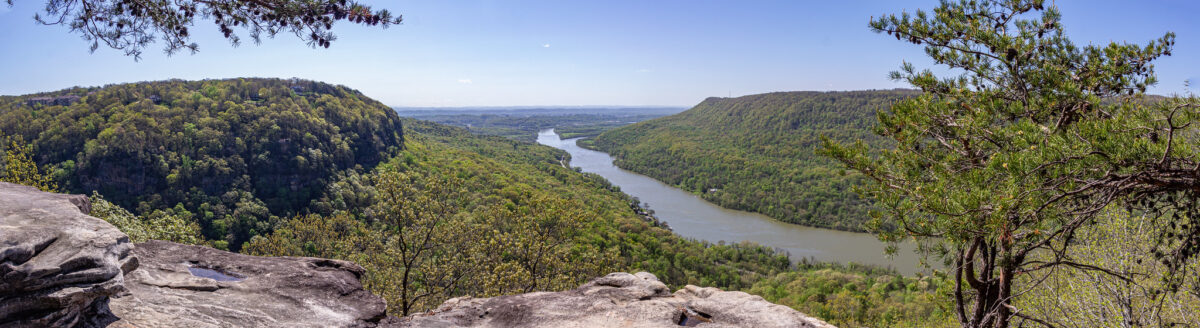
However, I did have a list of hiking trails I wanted to tackle, and that got completed, and then some.

We have hiked more in the last six months than I have hiked in my entire life. Some of the paths and trails we have done — ranging from easy flat gravel paths to moderate mountain hikes — were located at Big Soddy Creek Gulf, Greenway Farms, Booker T. Washington State Park, Lookout Mountain, Signal Mountain, Moccasin Bend, Prentice Cooper State Forest and Cloudland Canyon State Park.

It seemed like every time we finished one trail, we found another that we wanted to hike, and that is still the case now.

Getting outside kept me sane. It felt good to get our heart rates up, stretch our legs, make it to a gorgeous overlook, and feel accomplished.

We continued to hike as it got colder out, and we found that we quite enjoy winter hikes. I do not like winter time, as I get cold easily, but exercising like this is a good way to offset how our bodies feel in lower temperatures, and keep us more active throughout these months. I hope that we will continue to hike throughout January and February.

Hikes aside, I got a lot more exercise than ever before. I was averaging about three or four walks a day around my neighborhood. In September, I participated in a virtual 5K, and got a medal and a t-shirt for it. Walks were calming, and necessary for me, while I was going through bad bouts of anxiety.

Quitting my job was a huge risk, but it all worked out in the end. I was unemployed for about five weeks. Since Derek only taught two days a week last semester, we did a lot during the week days, to avoid crowds. We visited Wildflower Tea Shop for the first time, and it was nearly empty! We also went ice skating — something we had never done together — and there were only about half a dozen other people at the rink.

I hated working from home for my old job, but now I am thankful that I got to spend all of those months with our cat while she was still healthy, and I was home with her when she did get sick. All of that time that she spent on my lap every day are precious memories now.

I started my new job in early December, and I’m the happiest I have been in a long time. I thought I had wanted to leave journalism for marketing, but I discovered that journalism is where I am meant to me. This has put a lot of things into perspective.

I am cautiously looking forward to what 2021 may bring.