Derek and I have lived in Chattanooga for two and a half years now. During that time, we have hiked a lot of the area’s trails.
So many of these trails feature a waterfall. If you had told me three years ago that we would be hiking and seeing so many waterfalls, I would have thought you were crazy. Before this, the only waterfall I had seen was Niagara Falls.
This year, we have seen three new waterfalls: Foster Falls, Piney Falls, and Burgess Falls. I wondered, just how many waterfalls have we seen? In all, it comes to 13 waterfalls. I laughed to myself and thought about how a baker’s dozen is 13, so this is a hiker’s dozen.
Here is the list of 13 waterfalls, which a link to each corresponding blog post.
This is a wide-ranging list. Some of these are tiny, some of these are large and powerful. Some of these you can hike right up to the edge, and others you see from far away.
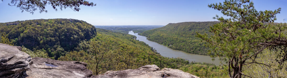
The first waterfall I saw on this list was also the furthest away, vantage point wise. This was Julia Falls. Better viewed after a lot of rainfall, it can be seen on the side of the mountain across from Julia Falls Overlook, which is reached from Signal Point. At the time I wasn’t aware of other local waterfalls, and I didn’t think it could get any better!
The easiest one to get to is Falling Water Falls, located on Signal Mountain. It’s a short walk from the parking lot. You view this waterfall from above.
The best trail for maximum views of a waterfall, in my opinion, is Foster Falls. The trail allows you to see the falls both far away and close, and on both sides.
The best overall trail and waterfall, I think, is Benton Falls. The trail is two miles there and back, but it is an easy gravel path. The waterfall is tall and large, and you can get right up close and go swimming, if you chose to do so.
A close second favorite is the waterfall trail at Cloudland Canyon State Park, where you can see three waterfalls. Winter falls is seen across the valley, on the side of the mountain, at the start of the trail. (A different trail does offer a water crossing at the bottom of Winter Falls.) The Waterfall Trail leads to both Hemlock and Cherokee falls.
What is your favorite waterfall that you’ve hiked to?
On Saturday we drove northwest from Chattanooga to Burgess Falls State Park, for a morning of hiking.
Burgess Falls State Park features three sections of a waterfall. I recommend going in the winter, so that you can see more of the river through the bare trees along the path.
A sign at the trailhead says that the trail is strenuous. I believe this may be because of the number of steps along the path, but Derek and I are intermediate-level hikers, and we thought it was fairly easy.
When we went, we had just had a week of rain, so the river and the falls were powerful and fast flowing.
This hike is great if you like maximum views. There are overlooks at the upper, middle, and lower falls.
We also walked an optional, short trail that leads to the top of the lower falls.
The path to the end of the lower falls is three quarters of a mile. There is a different, gravel path to take back to the parking lot, for a round trip total of 1.5 miles.
A section of a farm met up with the edge of the gravel path. Of course, I had to take photos of the cows!
We drove into the town of Sparta for lunch. We ate at The Coffee Collective, a nice café located on the historical square.
We walked around a bit, and saw a caboose on display, and a war memorial. We also walked on a pedestrian bridge across the Calfkiller River. Quite the name, huh? The river is named for a Cherokee chief.
We also shopped at the Fragrant Mushroom, a pottery store. The store had a calico cat named Josi. The prices were affordable, and the pieces were beautiful. We ended up buying a coaster and a mug.
A few weekends ago, Derek and I hiked to Piney Falls. We got lost a bunch of times, and we didn’t get the full experience that we had expected, but it was still a great hike.
The Piney Falls trail head is just north of Spring City, TN. It was about an hour’s drive away from where we live.
The Piney Falls trail is confusing, if you’re not sure of what to expect. This was our first time, and we ended up backtracking once, and turning off the correct trail twice.
The trail goes to both upper and lower Piney Falls. There is a junction and you can take either direction. The trail is a loop, but it can be avoided if you are not okay with a water crossing
We first went to upper Piney Falls, where we came out to the top of the falls.
It was here that we realized that we would have to cross the water. Since it was winter and there was a high flow of water, we decided that this was a bad idea. I would imagine that it is doable in summer months.
Because of this, we turned back around and headed back to the junction. If you go right, that takes you to upper Piney Falls, and left takes you to lower Piney Falls.
We got lost at least twice our way to lower Piney Falls. There are many different areas where it looks like the trail turns off. If you hike this trail, keep following alongside the rock cliffs.
We were treated to a great display of icicles along the cliffs.
At one point we were both sitting on a rock, frustrated and trying to look up trail maps and figure out our location on Google Maps. Just then, a couple came hiking through. They were familiar with the trail and led us to the waterfall.
The unique feature of Piney Falls is that you can walk behind the falls. I believe that if we had continued the hike behind the falls, and gone up the other side of the trail, we eventually would have come to the other side of the upper Piney Falls crossing. Maybe?
Unfortunately, there had just been a cold snap, so there was ice everywhere. I wanted to get a good shot of Piney Falls badly enough that I crawled on my hands and knees to get around!
Even though our hike was cut short and we missed half of the trail, the ice did create amazing photo opportunities!
This weekend Derek and I challenged ourselves to 24 hours of winter camping at Cloudland Canyon State Park.
We have camped in spring, summer, and fall, so winter was the last season left to try. We honestly did not know if we would like it or not. It could have very well been a disaster!
We did a lot of research, and we were mindful of the clothes that we packed, including thermals as a base layer and wool socks. We also packed our flannel lined sleeping bag, and two extra blankets.
We reserved Backcountry site #3, which you have to hike to from the trail head and parking lot. Last fall, we stayed at #5. Comparing the two sites, we like #3 better. It is a little closer of a walk from the trail head, and the site itself is prettier. The campsite has a stream running near it, and we had our own mini waterfall all to ourselves!
Convenience was a big factor at this site as well. The fire ring was right next to the picnic table. We had brought our camp chairs, but we never used them. We set our tent up right behind the picnic table. The outhouse was also just a few steps away. This outhouse was much cleaner than at site #5. Timing might have been a factor in this though, depending on how often they get serviced by volunteers.
Overall, we managed to stay warm. We had some frozen fingers and toes at time, but we brought hand warmers, which helped out. Getting into the sleeping bag at night was rough for the first five minutes, but our body heat quickly warmed us up. When we woke up in the morning, we realized that our breath had caused frost to form on the inside of the tent!
I am glad that Derek suggested last year that we start camping. We are still very much beginners, with not the greatest equipment. We have now camped twice at campgrounds, and have backpacked in twice. There are pros and cons for both types of camping. Campgrounds have more amenities, but there is nothing like being outside in the peace and quiet with no one else around.
We want to get hiking backpacks with frames, in order to carry everything on our backs. Things like that cost a lot of money though. In due time. We probably still bring way too much with us on each trip; it’s trial and error. We would like to camp at site #3 again in the spring, which would allow us shed some weight in the form of clothing layers and blankets.
I have been enjoying making YouTube videos. I videoed during our time camping, and I made a video from it. I think this is my favorite video yet!
Our first hike of 2022 was a good one, even though we did get a little lost!
We went to Foster Falls, part of the South Cumberland State Park. This is southwest of the Chattanooga area, about 45 minutes away.
Our hike was 2.3 miles long, but I think it would have been a little longer if we had gone the whole, right away.
We had cold, clear weather for the hike. When we started, it was 29 degrees with a windchill of 23. This allowed for beautiful ice formations.
The hike started out mostly flat, and then descended down to the bottom of Foster Falls. This was a rocky, stone step decent, but not too hard. We crossed a swinging bridge over Fiery Gizzard Creek as well.
After viewing the falls, and taking pictures of all the ice all around the edge of the water, the trail was a difficult ascent. There were times when we were literally scrambling over rocks on all fours.
It was here that we got confused, and accidentally cut the trail short. The trail is supposed to loop around, but there was a sign that said, “exit, climbers only,” which threw us off. So instead, we took the path that said, “Climbers loop access 1” and that was a short cut to the other end of the loop. When we realized our mistake, we doubled back a bit, not all the way though, to get the extra mileage in.
Thankfully, once you reach the top rim of the mountain, the trail levels out.
What I liked best about this trail was that the views of Foster Falls were maximized. We saw the falls from down below, up top, and from all sides. My favorite view was from above, where the light was hitting the falls just right to make rainbow colored mist.
There was even a smaller waterfall to the right of Foster Falls. I imagine that this smaller one is completely dried up in the summer. The trail actually crosses right over the top of this second waterfall. The edge has a cable barrier, so we safely looked over the edge and saw the water cascading down.
The hike ends (and starts as well) with an overlook where you can see Foster Falls from a further away vantage point.
We enjoyed this hike. It was just hard enough for our liking, and the right amount of mileage. The views of Foster Falls were fantastic. We are looking forward to finding new waterfall hikes throughout the rest of winter.
If you live in the Chattanooga area or are visiting Chattanooga and looking for a hike to do, consider Lula Lake Land Trust.
Lula Lake Land Trust is different from other outdoor recreational areas, in that it is a conservation area, and you need reservations to hike here. The Lula Lake Land Trust has open gate days, which are the first and the last weekend of every month. There is a $15 “conservation use fee” per carload.
Lula Lake Land Trust (LLLT) is a 501(c)(3) nonprofit organization established by the will of Robert M. Davenport in January of 1994. Dedicated to the preservation of lands located within the Rock Creek watershed on Lookout Mountain, the mission of LLLT is to preserve the natural and historic landscapes surrounding Rock Creek and its tributaries through conservation, education, and low-impact recreation.
Lulalake.org
Dates for reservations are listed two months out in advance, and dates sell out quickly. The reservations are timed, with the first group of people allowed to enter from 9-10 a.m.
We made our reservations a month out and hoped for good weather. If the weather forecast is not looking great and you want to cancel, you can get a refund if you do so at least 48 hours in advance.
There are multiple trails to choose from, and we picked the most popular, “The Out and Back,” which is 4.2 miles. This is a flat, gravel path, with little elevation change.
We timed our reservation, Oct. 31, for the forecasted peak foliage time, and we were not disappointed! I love photographing fall leaves, so this made our time here more special.
After a nice stroll, you come to a bridge that goes over Rock Creek. Just after this bridge, you will see the lower falls. There is a stone step path that leads down to these falls, filling into the conservation’s namesake, Lula Lake.
Head a little further up the trail and you will see the main falls, Lula Lake Falls. This waterfall is 120 feet high. I loved the pop of color at the top of the falls!
There are two trails leading down to the falls from the gravel path. The first one you come across is meant to use to come back up, after leaving the falls, because this one is steep. The second trail you come to, just a little further up from the first trail, is meant for making your way down to the falls.
There was plenty of space to walk around and check out the falls from different angles.
What I like the most is that the number of people allowed in are limited. Of course, we saw some people at the waterfalls, but it wasn’t crowded like some other hikes are. There were long stretches of time when we did not see any people on the trail.
At this point, heading back, we decided to deviate from the Out and Back Trail, and take the North Creek Trail back. I do NOT recommend this!
The North Creek Trail follows the creek and turns into the short Ford Trail, at which point you ford the river. We knew there would be a river crossing, but we didn’t know what we’d be up against.
The water was fairly deep, about mid-calf high. Derek took off his socks and shoes and rolled up his pant legs. I told him to go first, and I took his phone and recorded his crossing.
He barely made it a few steps when he slipped and fell! Luckily, he caught himself, and saved his butt from getting wet. Unluckily, he lost one of his shoes! There it went, floating down stream.
However, it was at this time that Derek met his trail guardian angel. A hiking couple were on the trail near us, and must have heard us exclaiming about the shoe, and he came running out on a section of rocks that jut halfway across the creek. With one of his hiker poles, he was able to retrieve the shoe.
After that, he made it safely across. Then it was my turn, and I was responsible for three shoes now! I decided to go across the creek from the rocks that were jutting out and go diagonally. This ended up being a little easier. I did have my moments when I almost fell though!
Once we were on the shore, we laughed about it. I’m glad we did it and we had the experience, but I wouldn’t want to do it again! It might be easier in the summer if the water levels are lower. After that, the North Creek and Ford Trails meet back up with the Out and Back Trail.
Overall, this was a great hike. Even with the extra water crossing that we weren’t planning on, it was a great, mostly easy hike, with great payoff in terms of views. I may consider coming back here again sometime, but I think we spoiled it for ourselves for another time by going during the fall with the beautiful leaves!
This past weekend, Derek and I did something that I never thought we would do. We camped at Cloudland Canyon State Park, but it wasn’t just typical camping in a campground.
We had a backcountry campsite, which is one of 10 campsites that are along the Backcountry Loop Trail. There is a parking lot at the trailhead, and everyone has to hike into their site. Some of the sites are closer, and some are further out than others. Our campsite was No. 5, which was not one of the closer ones, but not too far out either.
We do not have the big camping backpacks with the frames, we only have our regular school backpacks. In order to be able to haul everything we needed, we bought a little two-wheeled utility cart.
Our campsite was totally secluded. No. 5 had a little off shoot trail from the main trail, which we liked. The backcountry trail loop is a two mile trail, and I assume regular hikers, who are not camping, frequent through there.
This overnight camping trip was not perfect by any means. In fact, it was a comedy of errors. We learned our lesson many times over. We are not too scathed from our experience, and we want to camp there again, maybe even in the winter. Now we know how to do things right.
Our first lesson is to bring a hatchet next time, and skip the bundles of firewood. Because of the wood, we had to make two trips back and forth from the car to the campsite. We learned that campers are allowed to use any wood at the site, within reason, for campfires.
Things went fairly smoothly in the evening. Rain was in the forecast, so we hung up a tarp over our tent, to keep us dry. We have a beginner’s pop up tent, that is not water proof, but it suits our needs fine. It drizzled on and off while we ate dinner, but never amounted to much. We enjoyed the evening by the fire.
What we weren’t prepared for was how DARK it got at night. We’re used to camping near others, so you have everyone’s lantern light and campfires, and even the glow from buildings like the camp office or the bathhouse. It felt very weird, and somewhat scary, to be alone in the woods in the dark.
Before we went to bed, we opened up the top and side parts of our tent to expose the screens underneath, to let in air flow. It was quite warm when we went to bed, at 70 degrees.
It poured on and off all night long. We stayed nice and dry until suddenly, we were quite wet. I guess the wind must have shifted, causing the rain to come right into our tent! In the dim lantern light, Derek struggled to get the tent closed up again. Another lesson learned. Leave the tent fully closed when rain is in the forecast!
Our tent is small, so we can’t put everything inside. Our shoes were outside, underneath the tarp. But when it’s raining sideways, this does not help! Our shoes got soaked. Derek’s socks and jeans also got soaked, because they were folded up in the front corner of our tent, which was a full puddle of water by the time we got everything zipped up. Another lesson we took away from this is to bring an extra change of socks, and bring plastic bags for anything we want to stay dry.
The rain finally moved out at about 6:45 a.m. We got up, and again, were shocked at how dark it was. The wood was a little damp, and so were the Duralogs. Lesson No. Four: Duralog packaging is not water proof! Keep the Duralogs dry so they light easier!
We were both worried for a minute that we would not be able to get a fire started, therefore no warmth, no hot tea, and no breakfast. Things were tense, but the fire eventually did get going. It should also be mentioned that a cold front came through after the rain, so it was quite chilly early in the morning.
Once the sun came up and we had food in our stomachs, we could laugh at our misfortunes.
The Backcountry Loop Trail connects with the Bear Creek Trail. This is a trail that we had never been on, so we decided to check it out.
Unfortunately, we were steered wrong by the map that we had. The map listed that it was .5 miles to Bear Creek, before continuing on for another 7.1 miles. I thought to the creek and back would make a nice one mile hike. This was not so. Apparently the map was labeled incorrectly, or perhaps it was .5 miles from where it intersects with the Overlook Trail. Even the dotted line representing the direction of the trail was wrong, too.
The hike was easy at first, but then we went down a lot of switch backs to get down to the creek. We saw our first bright orange salamanders!
By the time we got back to the campsite, I think we had hiked nearly three miles total. It was a gorgeous hike, but we just were not prepared to go that far!
Once we got back, we started to pack up our campsite. We had to be out by 1 p.m. Imagine our surprise when a bunch of Boy Scouts, Boy Scout leaders, and some parents came into our campsite. They were very nice to us, but I was unhappy that they showed up too early. We had to rush through our packing up. We left at about 12:30, a full 30 minutes before they should have even been there.
All in all, we had a great time, and it was an adventure, to say the least.
I am so happy that hiking season is returning! There are some extreme hikers that will hike year round, but we prefer to do it while staying cool, and not having to carry twice as much water.
On Labor Day, Monday morning, we got up early and we headed to the Glen Falls Trail. We started out small; this wasn’t even a mile and a half, but it was a good start nonetheless.
We were on the trail at 7:30 a.m. and we had the trail and waterfall to ourselves.
We hiked this trail last January, and this time around we had a totally different experience. The water was practically gushing compared to last time.
We wanted to take off our shoes and go wading in the water this time. We brought a towel so we could dry off our feet afterward. Last time, we learned our lesson, that the wet rocks in the base of the falls were quite slippery in our hiking boots. Our bare feet offered more traction.
The water was cold, but refreshing. It was a little scary in some places, where it was deeper and the water was rushing fast, but we waded back and forth safely.
This is a fairly easy hike that is good for beginner hikers and families. The parking lot is small though, and fills up quickly. I recommend getting to this trailhead early, or going on a weekday.
Last week we hiked the Pot Point Trail, which is a 4 mile trail located near the Pot Point Cabin.
We discovered this trail after hiking the Ritchie Hollow Trail, because the two trails have the same parking lot.
The first mile of the Pot Point Trail is an elevation gain, but there is a descent after that and the rest of the trail is flat. The second half of the trail follows the Tennessee River.
The first mile also features mile marker posts every .10 of a mile. We were so happy to see marker “10” and know that the hardest part of the trail was over!
I have seen reviews of this trail where people mentioned that the river section of the trail is often flooded during a heavy rainfall. So, if you want to hike this trail, go during a period of dry weather.
At one part during the first half of the hike, we passed an area covered with brush. We walked past it and scared two turkeys! They immediately flew away. One flew straight up, and another took off into the distance. Neither of us had ever seen turkeys fly! It all happened so quick that I could not get a picture.
We also came across an old, abandoned shed/barn structure just off the trail. It seems like there have been plenty of visitors, because unfortunately there was a lot of litter in the area.
The end of the hike has a detour because of a landslide. We knew it was coming, and yet we still got lost. According to trail reviews, we are not the only ones that this happened to. During the detour, you follow the road for a little bit. You’re supposed to enter back on the trail, which we did see, but it was not obvious that it was where the detour ended. The trail head actually points in the opposite direction, which threw us off, and that is why we didn’t enter. Later on, checking the map, I saw that the trail does veer off in the correct direction eventually. Lots of people said that the last part of the trail follows the road, which is true to an extent, but like us, they must have not seen, or were confused by the trail picking back up again, and followed the road all the way back.
We hiked the Ritchie Hollow Trail on Wednesday morning, and a lot of lessons were learned.
Do not hike in warm, summer-like weather after a recent rain, because the humidity will be bad! Also, because of the humidity, we were sweating more, so we went through more water. We had to ration our water so we had enough to last the entire hike. Bring more water for warm weather hikes!
The Ritchie Hollow Trail is a newer trail, part of the Tennessee River Gorge Trust, which opened up in 2018.
The trailhead is just across the road from the Pot Point Cabin. I was excited to see this cabin, because I have seen pictures of it and I have read about it online.
According to trgt.org, “Pot Point Cabin was originally constructed in 1835 of hand-hewn logs and planks reclaimed from a flat boat that wrecked on the “Boiling Pot,” a nearby rapid in the Tennessee River.”
It is a beautiful two story log cabin, with views of the Tennessee River. The cabin is owned by the trust, and can be rented out. I looked into it once, and a two night stay is over $800! The cabin is large, so that price could be split up between parties. I had to satisfy myself by just looking at it from the outside, and taking a peek through the front window.
The full trail is 2.7 miles one way (5.4 miles round trip), but we did not complete the full trail. I might consider this during a return trip, but it would definitely have to be a colder day. Instead, we stopped at Blowing Wind Falls, which is 1.8 miles in, for 3.6 miles total. This seems to be a popular choice. We saw two other couples who did the same thing.
The hike to the falls is a steady incline the whole way. It flattens out at times, but barely long enough to catch your breath. The path is extremely rocky, and there are a lot of rock steps.
The hike features a few water crossings, which were pretty low when we passed through. In the first part of the hike we came across two smaller water falls.
We saw a lot of interesting things on this hike, including a lot of insects and flowers. My favorite was all of the mountain laurel shrubs. Mountain laurel grows in mountainous, forested areas. It is actually the state flower of Pennsylvania. We used to live in Pennsylvania for many years, and I had only seen it in the wild once. Here in this area of Tennessee, we see it all the time!
The pinkish-white blooms of Mountain Laurel dotting the trail.
Spotted this camouflaged toad hoping across the trail!
Another thing that we saw along the trail were remnants of old moonshine stills, noted as such on trgt.org.
The trail went up and up and up, until we felt like we couldn’t go any further. Then, up ahead a ways, we saw the sign pointing the way to the waterfall. We were so relieved to be able to get to the ending point, and sit and rest!
I should also say, once we got higher up in elevation, the humidity dissipated, which helped a bit. But the elevation was as grueling as ever! The coolness from the waterfall was welcoming once we reached it.
We knew it would be warm, so we planned on wading in the base of the falls. Blowing Wind Falls is perfect for that because you can get right up to the edge of the falls. I brought my water shoes, but Derek just cuffed his pants up. The water was so cold and felt so good.
The hike back was much easier, because then we were gradually descending all the way back down. Even though we were unprepared and we suffered a bit on the way going, we both said we would do this hike again!