On Christmas morning we did a short walk to see Falling Water Falls.
Falling Water Falls is just north of the town of Signal Mountain. It is about a 15 minute drive for us. Actually, it was about 20 minutes, but only because we had to take the long way around! W Road, the closest and fastest way up to Signal Mountain, was closed because of ice and snow!
It rained most of the day for us on Christmas Eve, and temperatures continually dropped. No snow by us, but up on Signal Mountain, it was cold enough for a little bit of snow! So in a way, we did get our white Christmas.
There is a small gravel parking lot at the trail head; Derek almost missed it driving by! About three cars can fit there. The trail is well maintained and easy to follow. It’s a short walk to the falls. You’ll know you’re on the right track because you can hear the creek and the falls as you get closer.
The path follows Little Falling Water Creek, and ends at the falls. If you’re careful, and daring enough, you can lean over enough to see the falls cascading down. (I got down on my belly and looked that way!) If you’re scared of heights, you can still see the edge of the falls well enough by standing on the nearby rocks that offer a higher vantage point.
The whole walk there and back is about .3 miles, but you can extend that a bit depending on how much you explore. We walked a little bit down the creek, as well as taking an upper level path for a bit before turning back around.
Also, I need to mention how cold it was! We tried to wait a few hours until mid-morning for it to warm up a bit, but driving up the mountain, we lost those few extra degrees anyway. It was about 23 degrees up there! We were mostly fine with layers, but our faces were so cold!
It was a nice, easy way to get outdoors and get a little bit of exercise on Christmas morning. The holidays are usually quiet for us, so this was a way to make the day feel special. I feel lucky to live in an area where there are so many scenic places nearby.
The trail leading to the falls. You can see the tiniest bit of snow!
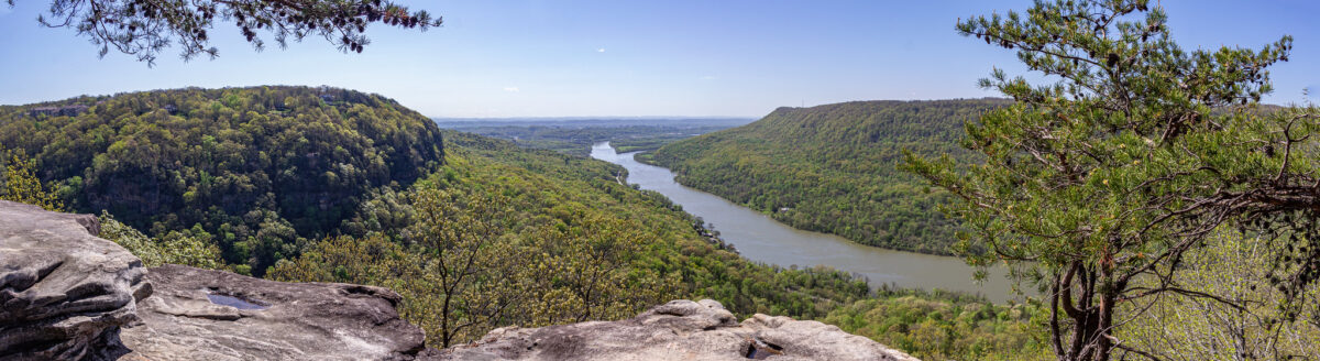
Yesterday we went to Snoopers Rock, which is within the Prentice Cooper State Forest, offering an amazing view of the Tennessee River Gorge. At that overlook, you see a bend in the river that curves around Elder Mountain.
From our place, it took about 35 minutes to get there. This is partially because once in Prentice Cooper State Forest, the road that leads to the trail, Game Reserve Road, has a 25 mph speed limit. I think the drive is well worth the view!
There is a parking lot on Game Reserve Road (listed as Game Reserve Road on the GPS, but signs there say Tower Road) at the start of the short trail to Snoopers Rock. Funnily enough, we accidentally took the “wrong” way! You can walk either the section of Mullen’s Cove Loop, which is on the right, or take Snoopers Rock Road, which is on the left. We didn’t know, and we walked the road. I suppose either way is fine, they both lead to Snoopers Rock!
It was a short walk, about 5-10 minutes, with some stops for photos of the season’s last fall foliage.
If you want an even shorter walk, there is a pull off spot with space for about 2-3 cars on Snoopers Rock Road, where you are just steps away from Snoopers Rock.
In the area, there are long trails such as the Mullen’s Cove Loop and Pot Point Loop, both of which lead to Snoopers Rock, so you can hike as little or as much as you want.
Since we went on a Wednesday morning, we were all by ourselves. We took as many pictures as our hearts content, and then ate our packed snacks on the rock while enjoying the scenery. With each place that we visit, I am reminded of how lucky we are to live in such a beautiful area. Chattanooga truly is the “Scenic City.”
Snoopers Rock Road.
I’m glad we got to see the last of some gorgeous leaves!
The purpose of this blog is to let our family and friends know about all of our adventures and day to day life in Chattanooga. This, of course, means that there will be some bad mixed in with the good.
If you’re a regular reader of Seeing the Scenic City, you’ll know that I’ve been struggling at my job for the past few months, as well as struggling with depression and anxiety that stemmed from the job.
I went on medication in early September. My anxiety has subsided, and when the medication worked, it allowed me to look at the work problems with clarity.
All of this leads me to say that Friday was my last day at my job. I put in three weeks’ notice in early October. With all honesty, I had wanted to quit my job since the summer months, so I am actually proud of myself for making it that much farther.
I will not go into too many details, but basically I realized that this was not the job for me. I was unhappy with the work I was doing. I was trying my best, but it became apparent that my best was not good enough.
This is probably not the smartest decision, financial wise. But it was the best decision for my health.
I have a few applications already out for some other positions, and I will keep looking for new jobs on a regular basis. In the meantime, I am looking forward to a (hopefully short) resting period.
In related news, yesterday we went on a challenging mountain hike. You can read about that here. One section of the trail lead to a beautiful overlook, where we could see the mountains on all sides, the river and a waterfall.
It was a great metaphor for what I am going through right now. Yes, things are hard, but if you put just one foot in front of the other, you will eventually get to the top of your mountain. Derek and I have made it over mountains before, and we will get over this one, too.
Today we hiked a segment of the Cumberland Trail, starting from Signal Point in the town of Signal Mountain, and going as far as the Middle Creek suspension bridge before turning back, for a total of 2.8 miles.
For some odd reason, I thought this hike would be easier than the hike we did two weeks ago on Lookout Mountain. I was wrong! This hike was extremely rocky. There were very few spots where the trail was flat and even. There were many spots where we had to climb or duck under large trees that had fallen in the path! We just had a large storm pass through this week, so I’m not quite sure if a lot of those trees had always been there, or if some of the damage was new. There was one spot where a tree took out a small section of a wooden walkway, and that seemed new.
We started at Signal Point, and first enjoyed the overlook for a few minutes. The trail starts to the right, and almost immediately there are a ton of steep steps, known as “The Mousetrap.” I am not sure why it is called that, but this is what the internet told me!
After all of the steps, the trail starts out fairly easily, but gets quite hard! There were more rocky areas than flat areas. You had to look down with almost every step.
I was glad that the trail was well marked (white squares either in paint, or screwed into the trees as metal plates) because there were quite a lot of sections where we thought, “Is this really the way we’re supposed to go?”
At 0.4 miles into the hike, you reach Julia Falls Overlook. I have read online that the falls is usually dry, or just a trickle. I am glad that we went after two days of heavy rain, so we could see it!
We had Julia Falls Overlook all to ourselves for about 15-20 minutes. A few groups came in, but by that point we were ready to head on our way. (On the way back, after lunch time, there were quite a few people there.)
After that, we followed the trail for about a mile to the Middle Creek suspension bridge. We were by ourselves for about 5 minutes, and then all of a sudden so many people showed up! We think it’s because the bridge is close to the Rainbow Lake Trail, another popular area.
This hike was hard, but only because of the uneven ground. It was slow going, for sure. If I were to do this again, I would probably only do the first section to Julia Falls. As always, I am glad we did it, and I felt accomplished (and exhausted). This makes two mountain hikes in three weeks!
The Signal Point Overlook at the start of the trail.
Possible storm damage?
The view from Julia Falls Overlook. The waterfall is in the far right of the photo.
As I am writing this, everything in my lower body hurts! Yesterday Derek and I did a hike on Lookout Mountain. We picked the trail from Cravens House to Sunset Rock, which is 3 miles out and back.
Derek and I like to hike, but 3 miles is the longest we have ever hiked here in Chattanooga. Usually we stick to 1-2 mile trails. This is also the hike that I have wanted to do the most since first hearing about this particular trail.
A sign at the start of the hike says to allow one to two hours round trip, but it took us almost four. This included at least 45 minutes out at Sunset Rock, though. We also took our time on the way up, stopping for lots of photos along the way.
We went on a beautiful, cool October day, which means that the trail was busy. We had to step off to the side many times to let other groups come and go.
The scenery was gorgeous on the trail. About half way to Sunset Rock you walk alongside towering rock cliffs. We even saw some rock climbers!
The trail starts out quite easy, which can be deceiving. I think that the closer you get to Sunset Rock, the harder the trail gets. If you come here, make sure to wear good hiking shoes, and always look down while walking! The trail is extremely rocky in some sections. The last section of the trail is a set of very steep stone steps. It wasn’t so bad going up, but coming down was much harder. My legs felt like jelly after that!
Sunset Rock is the end goal of this hike, 1.5 miles from Cravens House. Sunset Rock is a large flat area of rock on the side of the mountain, offering some fantastic views.
“In late October 1863, Confederate Generals James Longstreet and Braxton Bragg stood on Sunset Rock on the western side of Lookout Mountain. Below was the Union Army, attempting to open a supply line through the valley. Longstreet and Bragg planned their attack, which culminated in the Battle of Wauhatchie on October 28-29, 1863.”
www.nps.gov
Sunset Rock was very crowded while we were there, but everyone was respectful of each other, and even though we had to wait at some of the areas, everyone got their turns to check out the different views and take pictures.
Derek got some fantastic pictures of me. I am excited about how they turned out. Yes, they do look a little daring, but I felt safe the whole time. Well, I did freak out a tiny bit thinking Derek was too close to the edge getting some shots of me.
I would think that to avoid a crowd at Sunset Rock, you would either have to hike early in the morning, or maybe in the wintertime. However, the Sunset Rock area is large enough that everyone had their own little sections to themselves.
The hike back is considerably easier, and faster since it’s a gentle decline.
Back in the parking lot, we checked out the Cravens House, owned by Robert Cravens, which was there during the Civil War. Some fighting during the Battle of Lookout Mountain occurred by the house on Nov. 24, 1863. After the battle, the Union troops used the house as headquarters.
I am currently reading The Smoke At Dawn by Jeff Shaara, which is about the Battles of Chattanooga, one book in a series about the Civil War. It was thrilling to have just read about that battle taking place on Lookout Mountain, and then to be there the next day!
Yesterday was my birthday. To celebrate, we ate lunch at the Cookie Jar Cafe in Dunlap, Tennessee.
I had first heard about the Cookie Jar Cafe when I heard radio ads for Valentine’s Day reservations. I kept the name in my mind, tucked away for later.
Half of the draw of the Cookie Jar Cafe is the location. It is a family owned restaurant, and the family also owns a dairy farm on the same plot of land. While you’re waiting for a table (reservations are highly recommended) you can watch the cows grazing in the field.
The farm and restaurant are located in the Sequatchie Valley, so Walden’s Ridge looms overhead, making for a gorgeous backdrop.
They also have a small petting zoo behind the restaurant with goats, sheep, pigs and cows.
The food was excellent. I got a “meat and two” with chicken and dumplings, green beans and mac and cheese. An interesting side fact: I had never heard of a “meat and three” until I moved here. I figured it was a southern thing. Turns out it is, with its origins starting in Tennessee.
I am glad I went for the two sides instead of the three, because the portions were huge! It looked like I had barely made a dent on my plate. Next time I might try a sandwich. Derek got a burger with fries, and he said he enjoyed it, too.
The Cookie Jar Cafe is known for their desserts. We got an apple fry pie and a pumpkin spice cupcake to go.
On our way home, we stopped at the scenic overlook on the side of the highway, where we saw paragliders taking off.
It was a nice afternoon out. We will definitely come to the Cookie Jar Cafe again!
The outside of the Cookie Jar Cafe.
Such a beautiful scene!
The inside of the Cookie Jar Cafe. Notice all the cookie jars lined along the ceiling on the shelves! I even spotted my mom’s own cookie jar, a blue cat.
Happy birthday to me!
My meat and two. You can see Derek’s burger in the background.
The view from the scenic overlook on the way home.
My parents visited us for a long weekend and we did a lot of outdoor activities in an effort to try and stay safe.
Advertisements all across the south say to “See Rock City.” It’s been ingrained in my brain so much that I accidentally call the attraction “See Rock City,” when I’m supposed to drop the See. But now I can say that yes, I have seen it!
Rock City is at the top of Lookout Mountain in Georgia, and it features a 3/4 of a mile trail. The trail meanders through different themed areas featuring gardens and scenic views. You can sort of get a feel for what you are going to experience by looking at the website, but we truly did not know what we were in for until we experienced it ourselves.
Because of the pandemic, and a poorly timed computer update, our experience wasn’t exactly the best, but I can’t see how social distancing at Rock City is even possible. They are offering timed entry every 15 minutes. When I bought the tickets, we were the only four at 8:45. However, there was a computer update which backed up the 8:30, 8:45 and 9 a.m. entries. Even though we went to Rock City on a Friday morning, there were still so many people. At first we tried really hard to keep our distance from others but it was impossible. I wasn’t exactly happy about it, but we eventually just had to let our guard down a little and weave in and out of the other people as best as possible. We wore masks, but hardly anyone else did.
Some of my favorite parts of Rock City were the swinging bridge, the rainbow room and of course the view from Lover’s Leap. There are different shops and restaurants at the beginning of the trail, and some in the middle as well, around Lover’s Leap.
We went on a cloudy morning, and the Saharan dust cloud was approaching, so we did not have the best, clearest views. This is just an excuse to come back, maybe in the fall. Rock City is definitely something I would do again, and my parents agreed. They offer different types of events throughout the year. I am most looking forward to Enchanted Garden of Lights, which is their Christmastime event. You go at night and walk through the trail to see the Christmas lights.
The entrance.
There were a lot of cute, whimsical doors to walk through, which signified different sections of the trail.
The swinging bridge. There is an alternative, stone bridge if you are scared!
We probably did not see all seven states on this cloudy day …
At the top of Lover’s Leap.
The rainbow room.
Posing with Lover’s Leap in the background.
Inside Fairyland Caverns.
Fairyland Caverns featured scenes from fairy tales. Here is Little Red Riding Hood.
Mother Goose Village, featuring scenes from different nursery rhymes.
Derek and I love coffee shops. Going out for a drink and a light meal/snack is our favorite thing to do on the weekends. Our first date was actually at a coffee shop in our college town, so I guess that’s where the whole habit started.
Chattanooga, and the Chattanooga area, has many different coffee shops to choose from. I am highlighting our favorite five: Frothy Monkey, Milk & Honey, The Meeting House, Rembrandt’s Coffee House and Mayfly Coffee.
Full disclosure: I don’t even like coffee! So if you’re looking for coffee recommendations, I am sorry, but I cannot help you here. My husband on the other hand though loves coffee, and loves trying out the different flavors. I always order a chai latte at coffee shops.
The Frothy Monkey is my favorite overall. It is inside the Chattanooga Choo Choo Hotel. I love trains and history, so it’s a treat to be able to go there, walk around the hotel grounds a bit, and then get a drink at the Frothy Monkey. The location is gorgeous, with two levels of seating, and large exposed ceilings.
They have the most expansive menu too. However, I will admit they are a bit on the pricier side. We’ve ordered it all though, sandwiches, salads, and pastries. Most recently we ordered a huge cinnamon roll to share. It was delicious.
Milk & Honey was the first coffee shop we went to when we first moved to Chattanooga. I think their chai latte is the best out of all of these coffee shops. I’ll drink a super sweet chai but it’s not my favorite. (I’m looking at you Starbucks…) I prefer my chai to have spices in it, like cinnamon.
We have also ordered many different things off the menu there too. Derek likes the “Hot Mess” open sandwich, and I recommend their oatmeal, and their grilled cheese and tomato soup.
The downside to Milk & Honey is that it’s small, so there’s not much inside seating. There is plenty of outdoor seating, but it’s not really helpful when we’re in the middle of winter.
The Meeting House is in Red Bank, Tenn., a few miles north from downtown. This is the coffee shop that is closest to where we live. The Meeting House, like the name implies, is used for many community events. The coffee shop business side is closed on Sundays, and the building space is a church. Some people have warned us about this closure when we asked for coffee shop recommendations, but this doesn’t bother us, because I work on Sundays, so our weekend is Friday and Saturday.
Their menu is small, but the most reasonably priced out of this bunch. You can get a large bowl of grits for cheap there. Grits are one of my favorite breakfast foods, so I was sold from the start. You can also get an oatmeal bowl with cranberries and almonds in it. Yum!
Rembrandt’s Coffee House is in Bluff View Art District, and our go-to when we want to spend an afternoon out and about. We park in the free two-hour parking spots, get something to eat/drink at Rembrandt’s and then walk across the Walnut Street pedestrian bridge, which is just a few blocks over.
Rembrandt’s, like Milk & Honey, does not have much seating inside. This coffee shop is the most packed out of them all, at least from our experience. However, when it’s warmer out, their outdoor patio is my favorite.
They have an pretty good sized menu, and have an expansive pastry selection. I really enjoy their biscotti. I also like to order the Italian Flag sandwich, which is mozzarella, tomato and pesto.
The last but not least on this list is Mayfly Coffee, which is in Signal Mountain. We usually couple a visit to Mayfly with some other things in Signal Mountain, like a visit to Fairmount Orchard’s store or the Cookie Lady for some delicious tasting cookies.
A visit to Mayfly Coffee feels special. After living in Houston for three years, “going up the mountain” for the afternoon is like a mini adventure.
I like the ambiance of this coffee shop a lot. It is in a rustic looking building. The decorations inside are eclectic and adventurous. There is one wall that is covered with a mountain print that I’d love to have in my house! There is a nice outdoor seating area too.
So far to eat there, I’ve had a delicious breakfast bagel sandwich, and some cookies too. They have soups on their menu in the winter time that I’m planning on trying out next.
Of course there are so many more coffee shops than just these few I have listed here. Others that we have been to, but only once, include Mean Mug and Stone Cup Cafe. Do you like coffee shops? What are your favorites in your area, or in Chattanooga?
When I first moved to Chattanooga in September, Facebook started suggesting a lot of events for me to go to. Ketner’s Mill Country Fair was one of them, and I tucked the idea away in the back of my mind.
Ketner’s Mill is located in Whitwell, TN, about a half hour away from us, actually in the central time zone. It’s interesting and odd to be so close to the edge of a time zone barrier!
The Ketner family started working at the mill since 1842, according to www.ketnersmill.org. The mill ceased operations, but family members gathered together in the 1970s to restore the mill and house. It’s private property, but each year it’s opened to the public for the fair. The mill is not in production now, aside from that weekend. Visitors can buy cornmeal and watch it be made.
The fair featured a lot of vendors, wagon rides (we were lucky to get a whole wagon to ourselves) entertainment, blacksmith demonstrations and sorghum molasses demonstrations.
We learned that each of the vendors were all handpicked by the organizers of the fair. The items that each vendor had to sell were all nicely crafted. I stocked up on some homemade soaps, and we bought a small loaf of pumpkin bread to share at home. I only wish I had more money to purchase more items.
The fair grounds were beautiful as well. It was a cloudy day, and the clouds were low in the mountains. The mill was the focal point, and the Sequatchie River flowed behind it.
The drive to the fair was great as well, driving through some small towns and the Prentice Cooper State Forest. We pulled over many times to take photos of the scenery.
Low clouds in the mountains on our way to the fair.
Prentice Cooper State Forest.
Had to pull over for some small pops of color!
Ketner’s Mill and the Sequatchie River.
The view behind the mill.
Wagon ride with horses Mike and Ike.
Inside the Mill.
Blacksmith demonstrations.
Sorghum molasses demonstration.
A close up of the sugar cane being turned into juice.
One of the attractions on top of Lookout Mountain is Point Park. It is part of the Chattanooga and Chickamauga National Military Park.
The Battle of Lookout Mountain was fought November 24, 1863. It became known as the Battle Above the Clouds. It was a part of a larger few months long campaign to take over Chattanooga.
It was important that Union forces take control of Chattanooga because Chattanooga was the gateway to the deep south, and many railroads converged there.
History aside, Point Park has some beautiful observation points that overlook the mountains and downtown Chattanooga. There are some hiking trails on Lookout Mountain, but the paths that we saw seemed more difficult than we were willing to take on.
The New York Peace Memorial
This bend in the Tennessee River is known as Moccasin Bend.
An enlarged painting of The Battle Above the Clouds in the visitor’s center.