Ruby Falls

On Christmas Eve, we went to Ruby Falls with my parents. Out of all the major, popular attractions in the Chattanooga area, Ruby Falls was the last one for us to cross off.

We enjoyed Ruby Falls, however, there were both pros and cons.

Ruby Falls is an underground waterfall, located deep within Lookout Mountain. To get to the falls, you have to walk about half a mile through a cave system. Walking through the cave would have been more fun, if it hadn’t been crowded. This was most likely because we did this on Christmas Eve. Perhaps if someone went on a week day, they would have a better experience.

You have to walk through the cave single file, which doesn’t make for a good experience with the tour guide. We had to continuously walk through the cave, and the guide did not stop much to explain anything about the cave.

However, there was a video presentation at the start of the walk, where we learned about Leo Lambert, and his 1928 discovery of the cave and Ruby Falls, which he named after his wife. He went through the cave for 17 hours, much of that crawling, and he had no idea what he would discover. We did enjoy this presentation. But we felt like we missed out on learning more about caves in general.

As a photographer hobbyist, I found it frustrating to try to take photos inside of the cave. You had to take the photo quickly and move on, because as I mentioned earlier, we were continuously walking single file.

We only had to walk half a mile, but it seemed to take forever to get to our end point, because each time another tour group came through, we had to move up against the wall and let them pass.

Ruby Falls is the namesake and the highlight of the tour. When you first enter the large room, you can hear the waterfall, but barely see it. It is so dark in there! Thanks to a music and light show, about five minutes long, you can see Ruby Falls and be able to take some nice photos.

Leaving Ruby Falls was much easier, as our group had the right-away going back, and the other groups had to move over for us.

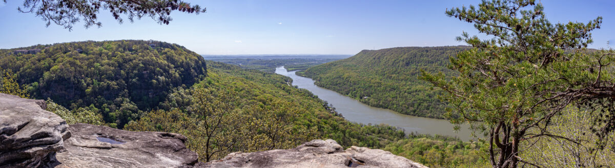
Also part of Ruby Falls is an overlook, which you get to by climbing a few floors of stairs. It offers a nice view point of Moccasin Bend.

Overall, I am glad I saw Ruby Falls. It’s no doubt impressive, and it’s neat to think that we were in the middle of Lookout Mountain, 1,120 feet below ground.

Ruby Falls itself is 80 feet high, and it’s pool is three feet deep. The water flows down through the mountain, and at some point it flows into the Tennessee River.

If you find yourself in Chattanooga, go visit Ruby Falls. You’ll be glad you did. Just don’t go on one of the busiest days of the year!

Ruby Falls0
Ruby Falls1
Ruby Falls2
Ruby Falls4
Ruby Falls13
Ruby Falls10
Ruby Falls34
Ruby Falls25
Ruby Falls45

Lula Lake Land Trust

If you live in the Chattanooga area or are visiting Chattanooga and looking for a hike to do, consider Lula Lake Land Trust.

Lula Lake Land Trust is different from other outdoor recreational areas, in that it is a conservation area, and you need reservations to hike here. The Lula Lake Land Trust has open gate days, which are the first and the last weekend of every month. There is a $15 “conservation use fee” per carload.

Lula Lake Land Trust (LLLT) is a 501(c)(3) nonprofit organization established by the will of Robert M. Davenport in January of 1994. Dedicated to the preservation of lands located within the Rock Creek watershed on Lookout Mountain, the mission of LLLT is to preserve the natural and historic landscapes surrounding Rock Creek and its tributaries through conservation, education, and low-impact recreation.

Lulalake.org
Lula Lake Land Trust4

Dates for reservations are listed two months out in advance, and dates sell out quickly. The reservations are timed, with the first group of people allowed to enter from 9-10 a.m.

We made our reservations a month out and hoped for good weather. If the weather forecast is not looking great and you want to cancel, you can get a refund if you do so at least 48 hours in advance.

There are multiple trails to choose from, and we picked the most popular, “The Out and Back,” which is 4.2 miles. This is a flat, gravel path, with little elevation change.

We timed our reservation, Oct. 31, for the forecasted peak foliage time, and we were not disappointed! I love photographing fall leaves, so this made our time here more special.

Lula Lake Land Trust24
Lula Lake Land Trust66
Lula Lake Land Trust17
Lula Lake Land Trust37

After a nice stroll, you come to a bridge that goes over Rock Creek. Just after this bridge, you will see the lower falls. There is a stone step path that leads down to these falls, filling into the conservation’s namesake, Lula Lake.

Lula Lake Land Trust39

Head a little further up the trail and you will see the main falls, Lula Lake Falls. This waterfall is 120 feet high. I loved the pop of color at the top of the falls!

Lula Lake Land Trust43

There are two trails leading down to the falls from the gravel path. The first one you come across is meant to use to come back up, after leaving the falls, because this one is steep. The second trail you come to, just a little further up from the first trail, is meant for making your way down to the falls.

There was plenty of space to walk around and check out the falls from different angles.

Lula Lake Land Trust57

What I like the most is that the number of people allowed in are limited. Of course, we saw some people at the waterfalls, but it wasn’t crowded like some other hikes are. There were long stretches of time when we did not see any people on the trail.

At this point, heading back, we decided to deviate from the Out and Back Trail, and take the North Creek Trail back. I do NOT recommend this!

The North Creek Trail follows the creek and turns into the short Ford Trail, at which point you ford the river. We knew there would be a river crossing, but we didn’t know what we’d be up against.

The water was fairly deep, about mid-calf high. Derek took off his socks and shoes and rolled up his pant legs. I told him to go first, and I took his phone and recorded his crossing.

He barely made it a few steps when he slipped and fell! Luckily, he caught himself, and saved his butt from getting wet. Unluckily, he lost one of his shoes! There it went, floating down stream.

However, it was at this time that Derek met his trail guardian angel. A hiking couple were on the trail near us, and must have heard us exclaiming about the shoe, and he came running out on a section of rocks that jut halfway across the creek. With one of his hiker poles, he was able to retrieve the shoe. 

After that, he made it safely across. Then it was my turn, and I was responsible for three shoes now! I decided to go across the creek from the rocks that were jutting out and go diagonally. This ended up being a little easier. I did have my moments when I almost fell though!

Once we were on the shore, we laughed about it. I’m glad we did it and we had the experience, but I wouldn’t want to do it again! It might be easier in the summer if the water levels are lower. After that, the North Creek and Ford Trails meet back up with the Out and Back Trail.

Lula Lake Land Trust78

Overall, this was a great hike. Even with the extra water crossing that we weren’t planning on, it was a great, mostly easy hike, with great payoff in terms of views. I may consider coming back here again sometime, but I think we spoiled it for ourselves for another time by going during the fall with the beautiful leaves!

Lula Lake Land Trust62
Lula Lake Land Trust56

Hike to Glen Falls

I am so happy that hiking season is returning! There are some extreme hikers that will hike year round, but we prefer to do it while staying cool, and not having to carry twice as much water.

On Labor Day, Monday morning, we got up early and we headed to the Glen Falls Trail. We started out small; this wasn’t even a mile and a half, but it was a good start nonetheless.

We were on the trail at 7:30 a.m. and we had the trail and waterfall to ourselves.

We hiked this trail last January, and this time around we had a totally different experience. The water was practically gushing compared to last time.

We wanted to take off our shoes and go wading in the water this time. We brought a towel so we could dry off our feet afterward. Last time, we learned our lesson, that the wet rocks in the base of the falls were quite slippery in our hiking boots. Our bare feet offered more traction.

The water was cold, but refreshing. It was a little scary in some places, where it was deeper and the water was rushing fast, but we waded back and forth safely.

This is a fairly easy hike that is good for beginner hikers and families. The parking lot is small though, and fills up quickly. I recommend getting to this trailhead early, or going on a weekday.

Glen Falls in Sept3
Glen Falls in Sept13
Glen Falls in Sept19
Glen Falls in Sept21

Glen Falls Trail

This past weekend Derek and I hiked the Glen Falls Trail.

This trail is located about halfway up Lookout Mountain, on the Tennessee side. This hike has varying lengths, depending on how long you want to make it. Our hike ending up being about 1.5 miles.

There is a small parking lot on the side of the road at the trailhead. The trail is an easy one, not too much elevation, not too rocky.

Your first glimpse of the falls is across the way while you’re on the trail. The trail leads to a small wooden bridge. The view of the waterfall is hidden from here, behind the rocks, but if you choose to keep going up, you have a better view of the waterfall from above.

The trail splits after the bridge. You can go straight, which I believe ends up at another parking lot, but we went to the right, up stone steps. You go through a small cave like tunnel. The trail follows the stream/creek, to the upper portion of the falls. I was not able to find out what this body of water is called.

You can get quite close to the upper falls, by walking across the stream of water. Be careful though! We found out the hard way that rocks covered by rushing water are extremely slippery!

From there, we also decided to climb up a bunch of rocks that offered a really nice view. This is not technically part of the trail, but this area does offer a lot in the way of exploring.

We were excited to go on this hike because last week we ordered hiking shoes. All this time we were wearing footwear that wasn’t really appropriate for trails. We both got Columbia shoes. I have always wanted hiking boots with red laces! Crossing the stream put the shoes to the test, and yes, they really are waterproof!

We have now seen five waterfalls on four different trails in the span of a month. When we first set out to hike in the fall months, I never expected that I’d be able to see so many different waterfalls, or any at all, for that matter!

Glen Falls Trail4
Glen Falls Trail8
Glen Falls Trail12
Glen Falls Trail18
Glen Falls Trail16
Glen Falls Trail15
Glen Falls Trail29
Glen Falls Trail36
Glen Falls Trail43
Glen Falls Trail46

Cloudland Canyon State Park

Yesterday we went to Cloudland Canyon State Park, located in Dade County, Georgia. Cloudland Canyon is a part of Lookout Mountain. This is about a 40 minute drive from where we live.

We have hiked a lot in the last six months, and Cloudland Canyon was the last major hike that was on my hiking to-do list. We hiked the 2 mile Waterfalls Trail.

This trail in particular is better after a large rain event, because these water falls are dependent on the amount of rain. The falls tend to be dry in the summer. The waterfalls are at their heaviest flow in the winter and early spring. This is why we saved this hike for last.

It rained all day Wednesday, and Saturday morning called for partly cloudy skies, so it was the perfect timing.

It costs $5 to get into the park, and you get a little tag to put on your windshield.

We parked at the West Rim Loop Parking Lot. We started off on the West Rim Loop Trail, before catching the Water Falls Trail. There is plenty of directional signage along the way.

Waterfall Trail70

You descend metal grate stairs to get down into the canyon. You reach a fork, with one direction leading to Cherokee Falls and the other to Hemlock Falls. We headed to Cherokee Falls first.

Waterfall Trail17
Waterfall Trail18

It was a cold morning, but the exercise quickly warmed us up, and we shed layers as we made our way down the canyon.

It is quicker to get to Cherokee Falls, with less steps, too. Plus, you can get close up to these falls, where the water cascades down into a pool. Because of that, I think more people probably go to Cherokee Falls.

Waterfall Trail41
Waterfall Trail41_1

After spending some time at Cherokee Falls, we retraced our steps back to the intersection, and then headed to Hemlock Falls.

Here you descend even further into the canyon, with many more steps. I wonder if anyone has ever counted?

Waterfall Trail22
Waterfall Trail56

Hemlock Falls is viewed from further away, on a wooden platform. I think that both falls are equally beautiful, but it’s a lot more work to get to Hemlock Falls.

Waterfall Trail61
Waterfall Trail63

Unfortunately, after viewing Hemlock Falls, it was time to turn back around and go up all the stairs that we just came down on. Here’s where the real exercise begins! There are plenty of sections with benches to stop and rest along the way, though.

We had a cold snap for two days, and because of all the recent rain, there was lots of ice everywhere, adding an extra layer of beauty to the surround nature. I enjoyed taking many photos of the ice.

Waterfall Trail31
Waterfall Trail50
Waterfall Trail51
Waterfall Trail52

I think this is one of my favorite hikes that I have done so far. There are different trails here, ranging from easy to difficult. There is a one mile overlook trail (half a mile out and back) that I think we will do next time, and combine that with just Cherokee Falls.

Rock City’s Enchanted Garden of Lights

This week we went to Rock City’s Enchanted Garden of Lights. This is the second time we have been to Rock City.

We have been to quite a few Christmas light set ups in a few different states. Most of them have been bigger than Rock City, but I think Rock City holds up to the others!

There was one initial disappointment. I was looking forward all night to taking a photo of the star on top of the waterfall, from the little balcony that juts out off to the side.

Turns out, we completely bypassed that area. The waterfall was actually shut off. We did see the star at the top and off to the side, though.

We went through the whole thing and ended up at the exit, and I said, “But what about the view of the waterfall????” At first I thought that we had missed an entire section, but that wasn’t possible because there were workers guiding us down the paths at each section.

Later that night, I was still concerned about it, so I watched YouTube walk through videos! When I realized that yes, we did see the whole thing, I felt better. But honestly, I think this is a missed opportunity on Rock City’s part!

My favorite section was the Arctic Kingdom, which was filled with penguins. There were tons of string lights there, and they were all in frosty colors like blue, purple and green, which just happens to be all my favorite colors. It was so pretty there.

We also enjoyed the view of the city lights from Lover’s Leap, and the synchronized lights to music in the Magic Forest. The synchronized lights reminded me of the lights in Hershey Park, Pennsylvania, which we have seen many times.

There were social distancing measures in place as usual. Tickets have to be bought online, where a timed entry is reserved. In certain spots where distancing was difficult, masks were required.

This was a nice holiday themed outing, and I recommend it to anyone looking for something festive to do in the Chattanooga area.

Enchanted Garden of Lights9
Enchanted Garden of Lights14
Enchanted Garden of Lights25
Enchanted Garden of Lights29
Enchanted Garden of Lights33
Enchanted Garden of Lights44
Enchanted Garden of Lights45
Enchanted Garden of Lights58
Enchanted Garden of Lights66

Lookout Mountain hike

As I am writing this, everything in my lower body hurts! Yesterday Derek and I did a hike on Lookout Mountain. We picked the trail from Cravens House to Sunset Rock, which is 3 miles out and back.

Derek and I like to hike, but 3 miles is the longest we have ever hiked here in Chattanooga. Usually we stick to 1-2 mile trails. This is also the hike that I have wanted to do the most since first hearing about this particular trail.

A sign at the start of the hike says to allow one to two hours round trip, but it took us almost four. This included at least 45 minutes out at Sunset Rock, though. We also took our time on the way up, stopping for lots of photos along the way.

We went on a beautiful, cool October day, which means that the trail was busy. We had to step off to the side many times to let other groups come and go.

The scenery was gorgeous on the trail. About half way to Sunset Rock you walk alongside towering rock cliffs. We even saw some rock climbers!

The trail starts out quite easy, which can be deceiving. I think that the closer you get to Sunset Rock, the harder the trail gets. If you come here, make sure to wear good hiking shoes, and always look down while walking! The trail is extremely rocky in some sections. The last section of the trail is a set of very steep stone steps. It wasn’t so bad going up, but coming down was much harder. My legs felt like jelly after that!

Sunset Rock is the end goal of this hike, 1.5 miles from Cravens House. Sunset Rock is a large flat area of rock on the side of the mountain, offering some fantastic views.

“In late October 1863, Confederate Generals James Longstreet and Braxton Bragg stood on Sunset Rock on the western side of Lookout Mountain. Below was the Union Army, attempting to open a supply line through the valley. Longstreet and Bragg planned their attack, which culminated in the Battle of Wauhatchie on October 28-29, 1863.”

www.nps.gov

Sunset Rock was very crowded while we were there, but everyone was respectful of each other, and even though we had to wait at some of the areas, everyone got their turns to check out the different views and take pictures.

Derek got some fantastic pictures of me. I am excited about how they turned out. Yes, they do look a little daring, but I felt safe the whole time. Well, I did freak out a tiny bit thinking Derek was too close to the edge getting some shots of me.

I would think that to avoid a crowd at Sunset Rock, you would either have to hike early in the morning, or maybe in the wintertime. However, the Sunset Rock area is large enough that everyone had their own little sections to themselves.

The hike back is considerably easier, and faster since it’s a gentle decline.

Back in the parking lot, we checked out the Cravens House, owned by Robert Cravens, which was there during the Civil War. Some fighting during the Battle of Lookout Mountain occurred by the house on Nov. 24, 1863. After the battle, the Union troops used the house as headquarters.

I am currently reading The Smoke At Dawn by Jeff Shaara, which is about the Battles of Chattanooga, one book in a series about the Civil War. It was thrilling to have just read about that battle taking place on Lookout Mountain, and then to be there the next day!

Lookout Mountain Hike12
Lookout Mountain Hike16
Lookout Mountain Hike25
Lookout Mountain Hike40
Lookout Mountain Hike64
Lookout Mountain Hike70
Lookout Mountain Hike76
Lookout Mountain Hike89
Lookout Mountain Hike97
Lookout Mountain Hike90
Lookout Mountain Hike100
Lookout Mountain Hike108
Lookout Mountain Hike112
Lookout Mountain Hike124

Little did we know …

Four years ago today, July 30, we were half way through our cross country move from Wellsboro, Pennsylvania to Houston, Texas. It was a 24 hour, 1,600 mile drive that took three days.

Our second day was a long 900-mile stretch, from Harrisonburg, Virginia to Picayune, Mississippi. Chattanooga is somewhere in the middle.

My parents had been to Chattanooga before. They reenacted the 150th Battle of Chickamauga (we used to be Civil War reenactors) and while there, they took a quick trip up to Chattanooga, to see the National Cemetery. My dad also loves trains and wanted to see the Andrews Raiders monument.

Tennessee was the first new state that we had driven through, so I think that was why I committed that part of the drive to memory, more so than any other sate.

My dad was driving to Houston with us, pulling the U-Haul trailer behind his truck. We were communicating with walkie talkies. As we were driving around Chattanooga on I-24 West, Dad was pointing out landmarks. From the road, we could see the flag pole on the top of the National Cemetery’s hill. Dad also made sure to point out Lookout Mountain, where the Civil War “Battle Above The Clouds” took place.

I specifically remember being in awe driving around Moccasin bend, around the mountain and the Tennessee River.

We took the Lookout Valley exit and stopped at a Subway for lunch. We ate in the parking lot. And then we were on our way, reaching the Georgia line just a few minutes later.

Little did we know that Chattanooga would be come our home three years later!

This past winter, I wrote an article about a new real estate office opening up in Lookout Valley. I drove past that Subway, and it was fun to reminisce. I think it would be fun to go back there and eat lunch again and think about how different things were the last time we ate there.

Here are some photos from that trip:

PA to TX_69.jpg
PA to TX_90.jpg
PA to TX_101.jpg
PA to TX_106.jpg
PA to TX_110.jpg
PA to TX_112.jpg

Southern Belle Riverboat

When my parents visited last weekend, we asked them what they wanted to do. The thing my mom wanted to do the most was ride on the Southern Belle riverboat.

There are a couple of different rides that you can take on the Southern Belle, which sails from downtown Chattanooga on the Tennessee River. The regular hour and a half sightseeing cruise is the most popular one and runs most frequently during the summer.

If you are looking for something a little more special, there are lunch and dinner cruises, sunset ones, fall foliage cruises and a cruise through the Chickamauga Dam locks. We picked the regular sightseeing one, mostly because that is what we were limited to, pandemic and all.

The sightseeing cruise comes with unlimited popcorn (not really unlimited, but you get a big bag that is plenty to go around) and souvenir plastic cups for unlimited soda. Honestly, we thought the popcorn was stale, and we didn’t get any soda, but we weren’t in it for the food. We did bring the cups home though!

The neat thing about the Southern Belle is that in order to dock, you have to first enter a larger dry docked riverboat. That’s where the gift shop is, where you buy tickets and there’s even the 3rd Deck Burger Bar.

The boat ride first takes you south about half way through Moccasin Bend, alongside Lookout Mountain. It was neat to be able to see the top of the New York Monument in Point Park, a place that Derek and I visited last fall. Then the boat turns back north and goes under all of the four main bridges near downtown. The trip is an hour and a half total.

The trip features narration, where you learn facts about the river, what you see on the shore and some of Chattanooga’s history. We were treated to music from the Southern Belle’s calliope, or steam organ.

We enjoyed our time on the cruise. This is something I would like doing again in the future.

Southern Belle10
The Southern Belle getting ready to dock.
Southern Belle13
The inside of the boat, where you would eat during lunch/dinner cruises.
Southern Belle15
Southern Belle32
The third deck of the boat. Too crowded for us! We were lucky and found a table by itself on the front of the second deck.
Southern Belle40
Lookout Mountain from the river.
Southern Belle49
One of many groups of barges.
Southern Belle58
Southern Belle62
Southern Belle67
The Market Street and Walnut Street bridges.
Southern Belle74
Southern Belle90

Rock City

My parents visited us for a long weekend and we did a lot of outdoor activities in an effort to try and stay safe.

Advertisements all across the south say to “See Rock City.” It’s been ingrained in my brain so much that I accidentally call the attraction “See Rock City,” when I’m supposed to drop the See. But now I can say that yes, I have seen it!

Rock City is at the top of Lookout Mountain in Georgia, and it features a 3/4 of a mile trail. The trail meanders through different themed areas featuring gardens and scenic views. You can sort of get a feel for what you are going to experience by looking at the website, but we truly did not know what we were in for until we experienced it ourselves.

Because of the pandemic, and a poorly timed computer update, our experience wasn’t exactly the best, but I can’t see how social distancing at Rock City is even possible. They are offering timed entry every 15 minutes. When I bought the tickets, we were the only four at 8:45. However, there was a computer update which backed up the 8:30, 8:45 and 9 a.m. entries. Even though we went to Rock City on a Friday morning, there were still so many people. At first we tried really hard to keep our distance from others but it was impossible. I wasn’t exactly happy about it, but we eventually just had to let our guard down a little and weave in and out of the other people as best as possible. We wore masks, but hardly anyone else did.

Some of my favorite parts of Rock City were the swinging bridge, the rainbow room and of course the view from Lover’s Leap. There are different shops and restaurants at the beginning of the trail, and some in the middle as well, around Lover’s Leap.

We went on a cloudy morning, and the Saharan dust cloud was approaching, so we did not have the best, clearest views. This is just an excuse to come back, maybe in the fall. Rock City is definitely something I would do again, and my parents agreed. They offer different types of events throughout the year. I am most looking forward to Enchanted Garden of Lights, which is their Christmastime event. You go at night and walk through the trail to see the Christmas lights.

Rock City5
The entrance.
Rock City15
Rock City33
There were a lot of cute, whimsical doors to walk through, which signified different sections of the trail.
Rock City35
Rock City42
The swinging bridge. There is an alternative, stone bridge if you are scared!
Rock City50
Rock City57
We probably did not see all seven states on this cloudy day …
Rock City62
At the top of Lover’s Leap.
Rock City70
Rock City79
The rainbow room.
Rock City86
Posing with Lover’s Leap in the background.
Rock City95
Inside Fairyland Caverns.
Rock City98
Rock City109
Fairyland Caverns featured scenes from fairy tales. Here is Little Red Riding Hood.
Rock City114
Mother Goose Village, featuring scenes from different nursery rhymes.
Rock City72
Can you make it through “Fat Man’s Squeeze?”
Rock City122