Glen Falls Trail

This past weekend Derek and I hiked the Glen Falls Trail.

This trail is located about halfway up Lookout Mountain, on the Tennessee side. This hike has varying lengths, depending on how long you want to make it. Our hike ending up being about 1.5 miles.

There is a small parking lot on the side of the road at the trailhead. The trail is an easy one, not too much elevation, not too rocky.

Your first glimpse of the falls is across the way while you’re on the trail. The trail leads to a small wooden bridge. The view of the waterfall is hidden from here, behind the rocks, but if you choose to keep going up, you have a better view of the waterfall from above.

The trail splits after the bridge. You can go straight, which I believe ends up at another parking lot, but we went to the right, up stone steps. You go through a small cave like tunnel. The trail follows the stream/creek, to the upper portion of the falls. I was not able to find out what this body of water is called.

You can get quite close to the upper falls, by walking across the stream of water. Be careful though! We found out the hard way that rocks covered by rushing water are extremely slippery!

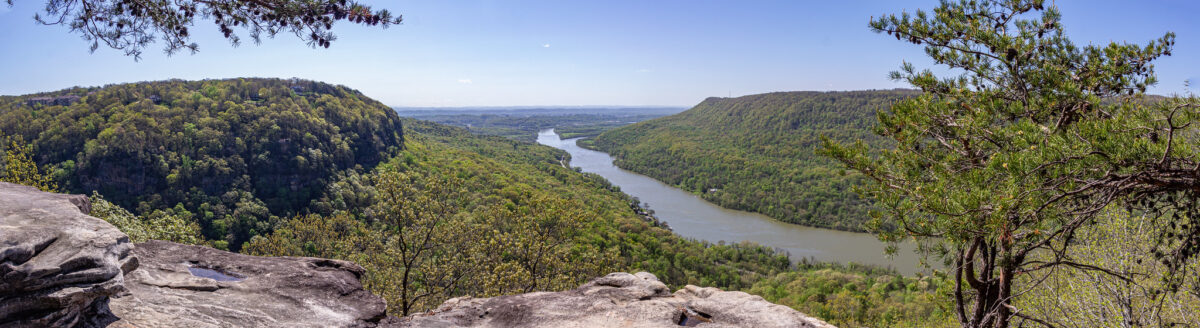
From there, we also decided to climb up a bunch of rocks that offered a really nice view. This is not technically part of the trail, but this area does offer a lot in the way of exploring.

We were excited to go on this hike because last week we ordered hiking shoes. All this time we were wearing footwear that wasn’t really appropriate for trails. We both got Columbia shoes. I have always wanted hiking boots with red laces! Crossing the stream put the shoes to the test, and yes, they really are waterproof!

We have now seen five waterfalls on four different trails in the span of a month. When we first set out to hike in the fall months, I never expected that I’d be able to see so many different waterfalls, or any at all, for that matter!

Glen Falls Trail4
Glen Falls Trail8
Glen Falls Trail12
Glen Falls Trail18
Glen Falls Trail16
Glen Falls Trail15
Glen Falls Trail29
Glen Falls Trail36
Glen Falls Trail43
Glen Falls Trail46

Sitton’s Gulch Trail

Yesterday we hiked Sitton’s Gulch Trail. This is the second hike that we have done that is a part of Cloudland Canyon State Park.

There are two options for hiking Sitton’s Gulch, because it is a there-and-back type trail. You can start the hike on either end, depending on how far you want to extend the hike.

If you start at the West Rim parking lot, you have to take part of the Waterfalls Trail down into the canyon to meet up with Sitton’s Gulch. If you go this way, the full trail is 6 miles long, three miles each way. When you’re coming back up, the stairs could be a strenuous ending.

The other end of the trail is located in Trenton, Georgia, in a residential neighborhood. We decided to start from this end of the trail. This way, we stopped our hike where Sitton’s Gulch meets the Waterfalls Trail, and did not have to go up or down any stairs. We have already been on the Waterfalls Trail, so we did not miss anything new. Doing the hike in this direction made it just over 4 miles.

Even though we shortened the hike, this is the longest hike Derek and I have ever done.

The trail is fairly easy, in that the path is mostly free from rocky and tree roots. However, there was a gradual incline the entire way, which was tiring at times.

The trail follows Daniel Creek, which was running fully after a few days of rain. There are many spots where the water flows down and over rocks, creating small waterfalls and rapids. There are many paths that split from the main trail to get a closer look at the creek.

The largest waterfalls are toward the end of the trail (or the beginning, depending on which way you go.)

One waterfall located high up even creates a small water crossing, depending on the amount of water flow.

We packed a lunch and enjoyed the view from the largest falls at the end, before turning back.

Cloudland Canyon has easily become my favorite place for hikes!

Sitton's Gulch Trail3
Sitton's Gulch Trail25
Sitton's Gulch Trail14
Sitton's Gulch Trail19
Sitton's Gulch Trail39
Sitton's Gulch Trail73
Sitton's Gulch Trail74
Sitton's Gulch Trail64
Sitton's Gulch Trail67

Reminiscing about 2020

With the ringing in of 2021, our first full year in Chattanooga has come to an end. The obvious thing to say is that 2020 was a ridiculous year.

On the surface, things looked pretty bad. I had three jobs this year, which is two jobs too many. I lost a job, resigned from a job, and had to go see a doctor to get on depression and anxiety medication. Mechanic bills for our car and veterinary bills piled up. Our cat passed away two weeks before Christmas, too. Add that all up and … ugh.

But if you dig a little deeper, I’d say things were good.

I’m thankful that we spent the pandemic in the Scenic City. We got outdoors more than ever this year, which was the safest thing to do.

I’m an adventurous soul. Not being able to travel in the past year has hurt me the most. But instead, we adventured around Chattanooga, seeing and doing things (mostly outdoors) that I had never expected to do.  

I have a Chattanooga area bucket list, and the majority of it has remained untouched. For instance, “Seeing a Lookouts baseball game” was impossible to cross off, because the entire season was cancelled. Likewise, we still haven’t taken a train ride with the Tennessee Valley Railroad. Trains are running, but I don’t feel comfortable going quite yet.

However, I did have a list of hiking trails I wanted to tackle, and that got completed, and then some.

We have hiked more in the last six months than I have hiked in my entire life. Some of the paths and trails we have done — ranging from easy flat gravel paths to moderate mountain hikes — were located at Big Soddy Creek Gulf, Greenway Farms, Booker T. Washington State Park, Lookout Mountain, Signal Mountain, Moccasin Bend, Prentice Cooper State Forest and Cloudland Canyon State Park.

It seemed like every time we finished one trail, we found another that we wanted to hike, and that is still the case now.

Getting outside kept me sane. It felt good to get our heart rates up, stretch our legs, make it to a gorgeous overlook, and feel accomplished.

We continued to hike as it got colder out, and we found that we quite enjoy winter hikes. I do not like winter time, as I get cold easily, but exercising like this is a good way to offset how our bodies feel in lower temperatures, and keep us more active throughout these months. I hope that we will continue to hike throughout January and February.

Hikes aside, I got a lot more exercise than ever before. I was averaging about three or four walks a day around my neighborhood. In September, I participated in a virtual 5K, and got a medal and a t-shirt for it. Walks were calming, and necessary for me, while I was going through bad bouts of anxiety.

Quitting my job was a huge risk, but it all worked out in the end. I was unemployed for about five weeks. Since Derek only taught two days a week last semester, we did a lot during the week days, to avoid crowds. We visited Wildflower Tea Shop for the first time, and it was nearly empty! We also went ice skating — something we had never done together — and there were only about half a dozen other people at the rink.

I hated working from home for my old job, but now I am thankful that I got to spend all of those months with our cat while she was still healthy, and I was home with her when she did get sick. All of that time that she spent on my lap every day are precious memories now.

I started my new job in early December, and I’m the happiest I have been in a long time. I thought I had wanted to leave journalism for marketing, but I discovered that journalism is where I am meant to me. This has put a lot of things into perspective.

I am cautiously looking forward to what 2021 may bring.

Falling Water Falls

On Christmas morning we did a short walk to see Falling Water Falls.

Falling Water Falls is just north of the town of Signal Mountain. It is about a 15 minute drive for us. Actually, it was about 20 minutes, but only because we had to take the long way around! W Road, the closest and fastest way up to Signal Mountain, was closed because of ice and snow!

It rained most of the day for us on Christmas Eve, and temperatures continually dropped. No snow by us, but up on Signal Mountain, it was cold enough for a little bit of snow! So in a way, we did get our white Christmas.

There is a small gravel parking lot at the trail head; Derek almost missed it driving by! About three cars can fit there. The trail is well maintained and easy to follow. It’s a short walk to the falls. You’ll know you’re on the right track because you can hear the creek and the falls as you get closer.

The path follows Little Falling Water Creek, and ends at the falls. If you’re careful, and daring enough, you can lean over enough to see the falls cascading down. (I got down on my belly and looked that way!) If you’re scared of heights, you can still see the edge of the falls well enough by standing on the nearby rocks that offer a higher vantage point.

The whole walk there and back is about .3 miles, but you can extend that a bit depending on how much you explore. We walked a little bit down the creek, as well as taking an upper level path for a bit before turning back around.

Also, I need to mention how cold it was! We tried to wait a few hours until mid-morning for it to warm up a bit, but driving up the mountain, we lost those few extra degrees anyway. It was about 23 degrees up there! We were mostly fine with layers, but our faces were so cold!

It was a nice, easy way to get outdoors and get a little bit of exercise on Christmas morning. The holidays are usually quiet for us, so this was a way to make the day feel special. I feel lucky to live in an area where there are so many scenic places nearby.

Falling Water Falls15
The trail leading to the falls. You can see the tiniest bit of snow!
Falling Water Falls17
Little Falling Water Creek
Falling Water Falls11
Falling Water Falls20
The edge of the falls.
Falling Water Falls23
Derek takes a peek over the edge.
Falling Water Falls33
Falling Water Falls1
Falling Water Falls38

Cloudland Canyon State Park

Yesterday we went to Cloudland Canyon State Park, located in Dade County, Georgia. Cloudland Canyon is a part of Lookout Mountain. This is about a 40 minute drive from where we live.

We have hiked a lot in the last six months, and Cloudland Canyon was the last major hike that was on my hiking to-do list. We hiked the 2 mile Waterfalls Trail.

This trail in particular is better after a large rain event, because these water falls are dependent on the amount of rain. The falls tend to be dry in the summer. The waterfalls are at their heaviest flow in the winter and early spring. This is why we saved this hike for last.

It rained all day Wednesday, and Saturday morning called for partly cloudy skies, so it was the perfect timing.

It costs $5 to get into the park, and you get a little tag to put on your windshield.

We parked at the West Rim Loop Parking Lot. We started off on the West Rim Loop Trail, before catching the Water Falls Trail. There is plenty of directional signage along the way.

Waterfall Trail70

You descend metal grate stairs to get down into the canyon. You reach a fork, with one direction leading to Cherokee Falls and the other to Hemlock Falls. We headed to Cherokee Falls first.

Waterfall Trail17
Waterfall Trail18

It was a cold morning, but the exercise quickly warmed us up, and we shed layers as we made our way down the canyon.

It is quicker to get to Cherokee Falls, with less steps, too. Plus, you can get close up to these falls, where the water cascades down into a pool. Because of that, I think more people probably go to Cherokee Falls.

Waterfall Trail41
Waterfall Trail41_1

After spending some time at Cherokee Falls, we retraced our steps back to the intersection, and then headed to Hemlock Falls.

Here you descend even further into the canyon, with many more steps. I wonder if anyone has ever counted?

Waterfall Trail22
Waterfall Trail56

Hemlock Falls is viewed from further away, on a wooden platform. I think that both falls are equally beautiful, but it’s a lot more work to get to Hemlock Falls.

Waterfall Trail61
Waterfall Trail63

Unfortunately, after viewing Hemlock Falls, it was time to turn back around and go up all the stairs that we just came down on. Here’s where the real exercise begins! There are plenty of sections with benches to stop and rest along the way, though.

We had a cold snap for two days, and because of all the recent rain, there was lots of ice everywhere, adding an extra layer of beauty to the surround nature. I enjoyed taking many photos of the ice.

Waterfall Trail31
Waterfall Trail50
Waterfall Trail51
Waterfall Trail52

I think this is one of my favorite hikes that I have done so far. There are different trails here, ranging from easy to difficult. There is a one mile overlook trail (half a mile out and back) that I think we will do next time, and combine that with just Cherokee Falls.

The easiest hike with the greatest view

Yesterday we went to Snoopers Rock, which is within the Prentice Cooper State Forest, offering an amazing view of the Tennessee River Gorge. At that overlook, you see a bend in the river that curves around Elder Mountain.

From our place, it took about 35 minutes to get there. This is partially because once in Prentice Cooper State Forest, the road that leads to the trail, Game Reserve Road, has a 25 mph speed limit. I think the drive is well worth the view!

There is a parking lot on Game Reserve Road (listed as Game Reserve Road on the GPS, but signs there say Tower Road) at the start of the short trail to Snoopers Rock. Funnily enough, we accidentally took the “wrong” way! You can walk either the section of Mullen’s Cove Loop, which is on the right, or take Snoopers Rock Road, which is on the left. We didn’t know, and we walked the road. I suppose either way is fine, they both lead to Snoopers Rock!

It was a short walk, about 5-10 minutes, with some stops for photos of the season’s last fall foliage.

If you want an even shorter walk, there is a pull off spot with space for about 2-3 cars on Snoopers Rock Road, where you are just steps away from Snoopers Rock.

In the area, there are long trails such as the Mullen’s Cove Loop and Pot Point Loop, both of which lead to Snoopers Rock, so you can hike as little or as much as you want.

Since we went on a Wednesday morning, we were all by ourselves. We took as many pictures as our hearts content, and then ate our packed snacks on the rock while enjoying the scenery. With each place that we visit, I am reminded of how lucky we are to live in such a beautiful area. Chattanooga truly is the “Scenic City.”

Snooper's Rock5
Snoopers Rock Road.
Snooper's Rock7
I’m glad we got to see the last of some gorgeous leaves!
SnoopersRock_Panorama
A panorama shot of the view from Snoopers Rock.
Snooper's Rock14
Snooper's Rock17
Snooper's Rock16
Snooper's Rock22
Snooper's Rock56
Snooper's Rock46
Snooper's Rock62
Snooper's Rock72
Enjoying all of these hiking adventures together!

Rainbow Lake and Bee Branch Trails

What are we to do on a sunny, gorgeous fall Monday, when I’m home for the foreseeable future and Derek is off, too?

We decided to go hiking, and we took the week day advantage by picking a normally busy trail. We hiked the Rainbow Lake Trail, along with the Bee Branch Trail, for a total of 2.3 miles.

The Rainbow Lake Trail is an easy and popular hike in Signal Mountain. From the trailhead it is 0.7 miles down to the dam.

Rainbow Lake was created in 1916 by damming Middle Creek. The lake was made for the tourists staying at the Signal Mountain Hotel.

The trail leads down to the bottom of the creek and the dam, which creates a pretty waterfall. There is a path that brings you to the top of the dam itself, if you’re brave enough to walk out there!

After spending time down at the dam, we headed to the Middle Creek suspension bridge. We were just here on Saturday, when we hiked from Signal Point.

We crossed the bridge, and started on the Bee Branch Trail, which does a wide loop around Rainbow Lake.

This entire trail was a skinny path, but it was easy to follow. It meanders up and down and around trees, rocks and trickling streams of water.

You cross the creek three times while on the Bee Branch Trail. There are also some cool rock formations along the way. We got lucky and saw some nice fall foliage, too.

It was a great idea to do this hike on a week day. We only saw six people total, with two couples. Everyone was headed in a different direction than we were, so they were quick passes. We were by ourselves 98 percent of the time.

Compared to the two other hikes we did recently (Signal Point to the Middle Creek bridge and Cravens House to Sunset Rock), this one was much easier. It was more of a flat trail, which allowed us to keep up a faster pace, and not strain our muscles as much by stepping over so many steep rocks.

Rainbow Lake and Bee Branch0
Rainbow Lake and Bee Branch11
Rainbow Lake and Bee Branch20
Rainbow Lake and Bee Branch37
Rainbow Lake and Bee Branch43
Rainbow Lake and Bee Branch49
Rainbow Lake and Bee Branch71
Rainbow Lake and Bee Branch72
Rainbow Lake and Bee Branch57

Cumberland Trail

Today we hiked a segment of the Cumberland Trail, starting from Signal Point in the town of Signal Mountain, and going as far as the Middle Creek suspension bridge before turning back, for a total of 2.8 miles.

For some odd reason, I thought this hike would be easier than the hike we did two weeks ago on Lookout Mountain. I was wrong! This hike was extremely rocky. There were very few spots where the trail was flat and even. There were many spots where we had to climb or duck under large trees that had fallen in the path! We just had a large storm pass through this week, so I’m not quite sure if a lot of those trees had always been there, or if some of the damage was new. There was one spot where a tree took out a small section of a wooden walkway, and that seemed new.

We started at Signal Point, and first enjoyed the overlook for a few minutes. The trail starts to the right, and almost immediately there are a ton of steep steps, known as “The Mousetrap.” I am not sure why it is called that, but this is what the internet told me!

After all of the steps, the trail starts out fairly easily, but gets quite hard! There were more rocky areas than flat areas. You had to look down with almost every step.

I was glad that the trail was well marked (white squares either in paint, or screwed into the trees as metal plates) because there were quite a lot of sections where we thought, “Is this really the way we’re supposed to go?”

At 0.4 miles into the hike, you reach Julia Falls Overlook. I have read online that the falls is usually dry, or just a trickle. I am glad that we went after two days of heavy rain, so we could see it!

We had Julia Falls Overlook all to ourselves for about 15-20 minutes. A few groups came in, but by that point we were ready to head on our way. (On the way back, after lunch time, there were quite a few people there.)

After that, we followed the trail for about a mile to the Middle Creek suspension bridge. We were by ourselves for about 5 minutes, and then all of a sudden so many people showed up! We think it’s because the bridge is close to the Rainbow Lake Trail, another popular area.

This hike was hard, but only because of the uneven ground. It was slow going, for sure. If I were to do this again, I would probably only do the first section to Julia Falls. As always, I am glad we did it, and I felt accomplished (and exhausted). This makes two mountain hikes in three weeks!

Signal Point Hike2
The Signal Point Overlook at the start of the trail.
Signal Point Hike15
Possible storm damage?
Signal Point Hike7
Signal Point Hike11
Signal Point Hike23
The view from Julia Falls Overlook. The waterfall is in the far right of the photo.
Signal Point Hike25
A close up of Julia Falls.
Signal Point Hike31
Signal Point Hike39
Signal Point Hike59
Much of the trail was extremely rocky.
Signal Point Hike65
The Middle Creek suspension bridge.
Signal Point Hike66
Signal Point Hike68
Signal Point Hike75
Signal Point Hike79
Signal Point Hike82

Lookout Mountain hike

As I am writing this, everything in my lower body hurts! Yesterday Derek and I did a hike on Lookout Mountain. We picked the trail from Cravens House to Sunset Rock, which is 3 miles out and back.

Derek and I like to hike, but 3 miles is the longest we have ever hiked here in Chattanooga. Usually we stick to 1-2 mile trails. This is also the hike that I have wanted to do the most since first hearing about this particular trail.

A sign at the start of the hike says to allow one to two hours round trip, but it took us almost four. This included at least 45 minutes out at Sunset Rock, though. We also took our time on the way up, stopping for lots of photos along the way.

We went on a beautiful, cool October day, which means that the trail was busy. We had to step off to the side many times to let other groups come and go.

The scenery was gorgeous on the trail. About half way to Sunset Rock you walk alongside towering rock cliffs. We even saw some rock climbers!

The trail starts out quite easy, which can be deceiving. I think that the closer you get to Sunset Rock, the harder the trail gets. If you come here, make sure to wear good hiking shoes, and always look down while walking! The trail is extremely rocky in some sections. The last section of the trail is a set of very steep stone steps. It wasn’t so bad going up, but coming down was much harder. My legs felt like jelly after that!

Sunset Rock is the end goal of this hike, 1.5 miles from Cravens House. Sunset Rock is a large flat area of rock on the side of the mountain, offering some fantastic views.

“In late October 1863, Confederate Generals James Longstreet and Braxton Bragg stood on Sunset Rock on the western side of Lookout Mountain. Below was the Union Army, attempting to open a supply line through the valley. Longstreet and Bragg planned their attack, which culminated in the Battle of Wauhatchie on October 28-29, 1863.”

www.nps.gov

Sunset Rock was very crowded while we were there, but everyone was respectful of each other, and even though we had to wait at some of the areas, everyone got their turns to check out the different views and take pictures.

Derek got some fantastic pictures of me. I am excited about how they turned out. Yes, they do look a little daring, but I felt safe the whole time. Well, I did freak out a tiny bit thinking Derek was too close to the edge getting some shots of me.

I would think that to avoid a crowd at Sunset Rock, you would either have to hike early in the morning, or maybe in the wintertime. However, the Sunset Rock area is large enough that everyone had their own little sections to themselves.

The hike back is considerably easier, and faster since it’s a gentle decline.

Back in the parking lot, we checked out the Cravens House, owned by Robert Cravens, which was there during the Civil War. Some fighting during the Battle of Lookout Mountain occurred by the house on Nov. 24, 1863. After the battle, the Union troops used the house as headquarters.

I am currently reading The Smoke At Dawn by Jeff Shaara, which is about the Battles of Chattanooga, one book in a series about the Civil War. It was thrilling to have just read about that battle taking place on Lookout Mountain, and then to be there the next day!

Lookout Mountain Hike12
Lookout Mountain Hike16
Lookout Mountain Hike25
Lookout Mountain Hike40
Lookout Mountain Hike64
Lookout Mountain Hike70
Lookout Mountain Hike76
Lookout Mountain Hike89
Lookout Mountain Hike97
Lookout Mountain Hike90
Lookout Mountain Hike100
Lookout Mountain Hike108
Lookout Mountain Hike112
Lookout Mountain Hike124

Hiking the Blue Blazes trail

I’m so glad that the weather has cooled down, and now we can resume hiking in full earnest! Last weekend we hiked the Blue Blazes trail, located in Moccasin Bend. This was our second hike in Moccasin Bend, the first one being the Brown’s Ferry Federal Road Trail. Read about that hike here.

To be honest, I’m not quite sure how long the trail actually is, because there is conflicting information. I saw it listed anywhere from 1.5 to 3 miles online, and the sign at the trail itself said it was 1.5 miles, but my phone recorded 2 miles worth of steps!

Either way, whether you think it is 1.5 or 3 miles, it is an easy, looped hike.

This is a woodsy trail, and the halfway point follows the river, with a path to get to the riverbank.

Another highlight of this hike is a swampy area that is covered in green algae. In that section, we found a tree that was heavy with fruit. We pulled some down and broke them open. They smelled like peaches. Don’t worry, we did not eat it! It was an interesting find though.

Blue Blazes Hiking Trail2
Blue Blazes Hiking Trail6
Blue Blazes Hiking Trail8
Blue Blazes Hiking Trail10
Blue Blazes Hiking Trail19
Blue Blazes Hiking Trail23
Blue Blazes Hiking Trail24
Blue Blazes Hiking Trail28
Blue Blazes Hiking Trail26