Cumberland Trail

Today we hiked a segment of the Cumberland Trail, starting from Signal Point in the town of Signal Mountain, and going as far as the Middle Creek suspension bridge before turning back, for a total of 2.8 miles.

For some odd reason, I thought this hike would be easier than the hike we did two weeks ago on Lookout Mountain. I was wrong! This hike was extremely rocky. There were very few spots where the trail was flat and even. There were many spots where we had to climb or duck under large trees that had fallen in the path! We just had a large storm pass through this week, so I’m not quite sure if a lot of those trees had always been there, or if some of the damage was new. There was one spot where a tree took out a small section of a wooden walkway, and that seemed new.

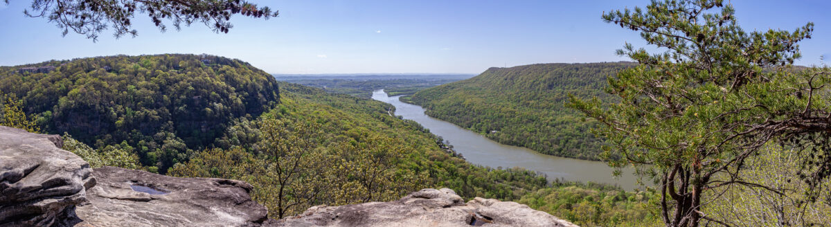
We started at Signal Point, and first enjoyed the overlook for a few minutes. The trail starts to the right, and almost immediately there are a ton of steep steps, known as “The Mousetrap.” I am not sure why it is called that, but this is what the internet told me!

After all of the steps, the trail starts out fairly easily, but gets quite hard! There were more rocky areas than flat areas. You had to look down with almost every step.

I was glad that the trail was well marked (white squares either in paint, or screwed into the trees as metal plates) because there were quite a lot of sections where we thought, “Is this really the way we’re supposed to go?”

At 0.4 miles into the hike, you reach Julia Falls Overlook. I have read online that the falls is usually dry, or just a trickle. I am glad that we went after two days of heavy rain, so we could see it!

We had Julia Falls Overlook all to ourselves for about 15-20 minutes. A few groups came in, but by that point we were ready to head on our way. (On the way back, after lunch time, there were quite a few people there.)

After that, we followed the trail for about a mile to the Middle Creek suspension bridge. We were by ourselves for about 5 minutes, and then all of a sudden so many people showed up! We think it’s because the bridge is close to the Rainbow Lake Trail, another popular area.

This hike was hard, but only because of the uneven ground. It was slow going, for sure. If I were to do this again, I would probably only do the first section to Julia Falls. As always, I am glad we did it, and I felt accomplished (and exhausted). This makes two mountain hikes in three weeks!

Signal Point Hike2
The Signal Point Overlook at the start of the trail.
Signal Point Hike15
Possible storm damage?
Signal Point Hike7
Signal Point Hike11
Signal Point Hike23
The view from Julia Falls Overlook. The waterfall is in the far right of the photo.
Signal Point Hike25
A close up of Julia Falls.
Signal Point Hike31
Signal Point Hike39
Signal Point Hike59
Much of the trail was extremely rocky.
Signal Point Hike65
The Middle Creek suspension bridge.
Signal Point Hike66
Signal Point Hike68
Signal Point Hike75
Signal Point Hike79
Signal Point Hike82

Fall photos

Last year Derek and I found a stretch of trees that really pop with color during the fall. The trees are on the edge of a elementary school parking lot, so it works out well to take photos there during the weekend.

We drove past that area early last week and noticed the reds and oranges. I was looking forward all week to taking more photos!

I love having our own, established spot. And I also love that it’s nearby, too.

I’m thankful that Derek is patient and takes many photos (literally over 150) so he knows for sure that I will like some of them. It’s quite funny that I snap about five photos of Derek, and he’s satisfied.

I love taking photos, mainly of outdoor related landscapes. I would say that my absolute favorite is fall leaves though. I’m truly happy when I’m photographing a colorful tree!

Fall photos6
Fall photos8
Fall photos22
Fall photos37
Fall photos1
Fall photos15
Fall photos44
Fall photos42
Fall photos51

Lookout Mountain hike

As I am writing this, everything in my lower body hurts! Yesterday Derek and I did a hike on Lookout Mountain. We picked the trail from Cravens House to Sunset Rock, which is 3 miles out and back.

Derek and I like to hike, but 3 miles is the longest we have ever hiked here in Chattanooga. Usually we stick to 1-2 mile trails. This is also the hike that I have wanted to do the most since first hearing about this particular trail.

A sign at the start of the hike says to allow one to two hours round trip, but it took us almost four. This included at least 45 minutes out at Sunset Rock, though. We also took our time on the way up, stopping for lots of photos along the way.

We went on a beautiful, cool October day, which means that the trail was busy. We had to step off to the side many times to let other groups come and go.

The scenery was gorgeous on the trail. About half way to Sunset Rock you walk alongside towering rock cliffs. We even saw some rock climbers!

The trail starts out quite easy, which can be deceiving. I think that the closer you get to Sunset Rock, the harder the trail gets. If you come here, make sure to wear good hiking shoes, and always look down while walking! The trail is extremely rocky in some sections. The last section of the trail is a set of very steep stone steps. It wasn’t so bad going up, but coming down was much harder. My legs felt like jelly after that!

Sunset Rock is the end goal of this hike, 1.5 miles from Cravens House. Sunset Rock is a large flat area of rock on the side of the mountain, offering some fantastic views.

“In late October 1863, Confederate Generals James Longstreet and Braxton Bragg stood on Sunset Rock on the western side of Lookout Mountain. Below was the Union Army, attempting to open a supply line through the valley. Longstreet and Bragg planned their attack, which culminated in the Battle of Wauhatchie on October 28-29, 1863.”

www.nps.gov

Sunset Rock was very crowded while we were there, but everyone was respectful of each other, and even though we had to wait at some of the areas, everyone got their turns to check out the different views and take pictures.

Derek got some fantastic pictures of me. I am excited about how they turned out. Yes, they do look a little daring, but I felt safe the whole time. Well, I did freak out a tiny bit thinking Derek was too close to the edge getting some shots of me.

I would think that to avoid a crowd at Sunset Rock, you would either have to hike early in the morning, or maybe in the wintertime. However, the Sunset Rock area is large enough that everyone had their own little sections to themselves.

The hike back is considerably easier, and faster since it’s a gentle decline.

Back in the parking lot, we checked out the Cravens House, owned by Robert Cravens, which was there during the Civil War. Some fighting during the Battle of Lookout Mountain occurred by the house on Nov. 24, 1863. After the battle, the Union troops used the house as headquarters.

I am currently reading The Smoke At Dawn by Jeff Shaara, which is about the Battles of Chattanooga, one book in a series about the Civil War. It was thrilling to have just read about that battle taking place on Lookout Mountain, and then to be there the next day!

Lookout Mountain Hike12
Lookout Mountain Hike16
Lookout Mountain Hike25
Lookout Mountain Hike40
Lookout Mountain Hike64
Lookout Mountain Hike70
Lookout Mountain Hike76
Lookout Mountain Hike89
Lookout Mountain Hike97
Lookout Mountain Hike90
Lookout Mountain Hike100
Lookout Mountain Hike108
Lookout Mountain Hike112
Lookout Mountain Hike124