Hike to Mushroom Rock and Suck Creek suspension bridge

We have hiked our longest hike to date, 5.75 miles. This was purely by accident, thanks to some poorly marked trails.

Here was our original plan: Start out at Shackleford Ridge Park, in Signal Mountain, and catch a trail that would take us to Mushroom Rock. From the rock, we would take the Cumberland Trail down to the Suck Creek suspension bridge. Once at the bridge, we would turn around and come back the way we came. This was supposed to be maybe a four mile hike at most.

We should have known that we would get lost, because there are few maps with the trail from Shackleford Ridge to Mushroom Rock. We could not use our Google Maps GPS to make sure we were staying on the correct trail. Once at Mushroom Rock, it is labeled more clearly.

I tried to read up as much as I could on the trail, and took a screen shot of the one map I did find, which in the end got us more lost than anything, I think. The issue is that there are multiple trails and unmarked paths that cross. Which one to take? We did not know.

We ended up walking about a mile, including backtracking a few times, before we got on the right trail. However, we did see some nice things along the way, and we got plenty of extra exercise in, so we’re not really complaining. When we saw that first sign for Mushroom Rock, we were relieved!

Mushroom Rock and Suck CreekMushroom Rock and Suck Creek0_6
A little stream crossing that was fun, but we technically didn’t have to do, seeing as we were lost at this point, but we didn’t know it yet.
Mushroom Rock and Suck CreekMushroom Rock and Suck Creek0_8
Finally on the right path!

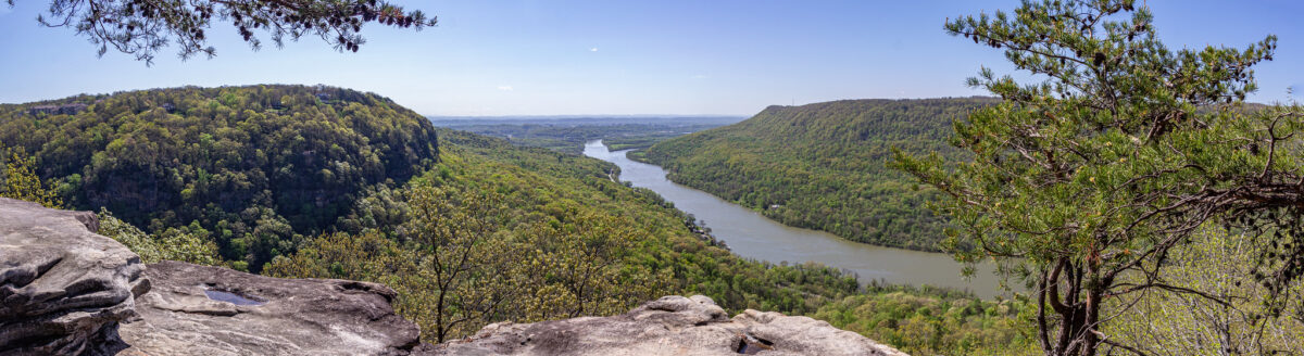
Mushroom Rock is a really neat formation. I had seen pictures of it, but it’s still impressive when seeing it in person for the first time.

Mushroom Rock and Suck CreekMushroom Rock and Suck Creek0_13
Mushroom Rock.
Mushroom Rock and Suck CreekMushroom Rock and Suck Creek0_15

From there we had to jump on the Cumberland Trail, where we got lost again! We were on the Cumberland Trail, but we quickly realized we were going in the opposite direction that we wanted. Thankfully a nice couple passing by pointed us in the right direction. We had gone to the left, but we had wanted to go right, behind the rock.

From there to the Suck Creek Suspension bridge, it is a switch back trail that heads down into the gorge.

Mushroom Rock and Suck CreekMushroom Rock and Suck Creek0_20
We saw some melting ice in a shaded spot on the switchback part of the trail.

We stopped at a large suspension bridge, that we had all to ourselves. Just before the bridge, there is a primitive hike-in camping site, with a few fire pits and benches made out of logs. We both decided we would love to camp here. It would definitely be easier since we know now the right way to go!

Mushroom Rock and Suck CreekMushroom Rock and Suck Creek0_24
Mushroom Rock and Suck CreekMushroom Rock and Suck Creek0_25
View from the suspension bridge.
Mushroom Rock and Suck CreekMushroom Rock and Suck Creek0_34

The hike back up the gorge was tiring! We had to stop many times to catch our breath. Once past Mushroom Rock, we got lost again! It was the same issue as last time, too many intersections with too many crossed paths. But we will remember for next time! We were thankful to get back to the car and rest our legs!

Two favorite restaurants

We have “rediscovered” two restaurants in our area.

When I say rediscovered, I mean that we ate at these places once before, before the pandemic. Then we stuck closer to home, and over the year, forgot how much we enjoyed our meals at these restaurants.

The first restaurant is Home Folks in Soddy-Daisy. Like the name implies, this is a casual setting, and the food reminds you of a good home cooked meal.

I enjoy the overall feeling of this place. The tables are covered with blue and white checkered table cloths, and there is old fashioned country-like décor.

This used to be a buffet-style restaurant. They have done away with the buffet, but they still serve all of the same great dishes. Now, you pick which food you want off the menu, and the waiter will bring all of the dishes to your table. You can eat as much or as little of all the dishes as you want.

Some of my favorites here are the pork and kraut, creamed corn, mashed potatoes and mac and cheese. There is also dessert too, with choices like banana pudding and different kinds of pie. Too be honest, I am usually too full after eating here to manage any dessert!

The buffet type food is the main staple, but they also have a small menu that changes each day.

IMG_1402
IMG_1399
I love the country-type atmosphere!
IMG_1401
I love the look of this stove!
IMG_1398
Yum! So many choices at Home Folks!

The second restaurant is 1885 Grill, in the St. Elmo neighborhood. This is a local chain, with two other locations.

The first time we ate here, I ordered on the boring side and got a chicken sandwich, but it was delicious, regardless.

This time, we came on a Saturday, and got to experience their weekend brunch. We were both very happy with our meals.

Derek got the biscuits and gravy with eggs. I have always been leery of biscuits and gravy, and he let me try a small taste. I liked it!

I got a breakfast plate with eggs, bacon, toast and grits. I love grits, and these were without a doubt the best grits I have ever had. They were nice and creamy, and flavorful too.

We went for brunch again, quite soon after our first time experiencing the brunch menu. This time I got the biscuits and gravy with eggs, with a side of grits, and he got the Belgian Waffle Bananas Foster, with a side of bacon. Another thumbs up from both of us.

There are so many other dishes on their menu I would like to try, such as the shrimp and grits (I know I will love the grits part!) and their gumbo.

Plus, when it gets warmer out, they have a nice outdoor seating area, which is right across the street from the Incline Railway.

IMG_1471
The outdoor seating at 1885 Grill is really nice, in warmer temperatures of course.
IMG_1465
IMG_1470
Brunch at 1885 Grill is quickly becoming a favorite!

Stringer’s Ridge

Last weekend we hiked around Stringer’s Ridge Park, which is close to downtown. It is a ridge that overlooks the city.

This is definitely not a hike to do if you’re looking to get away from it all and by fully immersed in nature. You will hear road noise and be quite close to some houses. But, it will do in a pinch if you want to get outside and get some exercise.

There are quite a few trails, some of them shared by bicyclists. The trails offer elevation changes and twists and turns.

The highlight is the overlook on the Cherokee Trail, which has a good view of downtown and the bridges over the river.

Some of the trails we took were the Cherokee Trail, the Double J, (which is a part of the bigger Blue Loop) and the short path to Old Baldy, which is the highest point of the ridge.

However, don’t do what we did, and don’t park by the tunnel on Cherokee Blvd! That particular entryway has been marked as closed for a long time. We have seen people’s photos on social media and reviews, so we knew the park wasn’t actually closed. So we went over the closed gate. We soon came to a part of the trail that was washed out! So it’s closed for a good reason! However, some people probably did the same that we did, so there was a worn path to follow down and around. Parking is available in different sections, so I’d advise to park somewhere else and avoid that section of the trail.

We hiked about three miles total, and it’s nice to know that there’s a place nearby if we don’t feel like driving further.

Stringer's Ridge2
Stringer's Ridge11
Stringer's Ridge10
Stringer's Ridge17
Stringer's Ridge18
An old structure we came across on the Blue Loop trail.
Stringer's Ridge22
On top of Old Baldy. Lookout Mountain is in the background.

Naughty Cat Cafe

The cold and off and on rainy weather has been keeping us inside more than we’d like for the past couple of weeks. What could we do that was new, and inside?

We have passed Naughty Cate Cafe, at the base of Lookout Mountain, many times, and said each time that we needed to go there some day. Well that day was last Saturday.

I’m not sure how the cafe operates in a non-COVID-19 world, but right now, they ask to book one-hour time slots in advance. I think they do walk-ins, but there’s a good chance that the cafe is full, so it is probably better to just make the reservation to guarantee a spot when you want to go.

It costs $13 per person. The fee includes non-alcoholic drinks. There is a tea and coffee bar set up at the front. Alcoholic drinks and food items like cookies, brownies and cupcakes are extra.

Naughty Cat Cafe has been open for a little less than two years, and they have had over 600 adoptions! All of the cats at the cafe are adoptable, and they come from two partnering shelters.

When we went, there were 38 cats! Inside the lounge there are plenty of spaces to sit, but you may be sharing your seat with a cat! There are also plenty of toys for the cats to play with.

We definitely fell in love with a few kitties, but we are strictly a two-cat household at the moment. You are not required or expected to adopt a cat from the cafe. Some people go just to de-stress and get in some cute cat time.

There was one black kitty named Fiddlestix that we liked. She was new to the cafe, and was in the “shy” room, a small closed off area for cats to slowly get used to the cafe. Another kitty, Mitsuu, had only three legs and was SO friendly.

Naughty Cat Cafe has an Instagram page, and I am going to enjoy following it for the next few weeks, and see which ones have been adopted.

I would love to go again. In just a few weeks, most if not all of the cats could be all new ones! However, I would probably go once the pandemic is over, or at least when more people have been vaccinated. Everyone kept their masks on inside, but I personally felt like there were too many people there. I am still glad we went though. It was a different experience.

Naughty Cat Cafe9
Naughty Cat Cafe17
Naughty Cat Cafe6
Naughty Cat Cafe3
Naughty Cat Cafe37
Fiddlestix, one of our favorites. I hope she finds a good home soon.
Naughty Cat Cafe30
Naughty Cat Cafe15
Naughty Cat Cafe27

Reflection Riding Arboretum and Nature Center

Yesterday we hiked the trails at Reflection Riding Arboretum and Nature Center for the first time.

One of Derek’s classes this semester, professional practices, is partnering with the Arboretum to help them with graphic design work, such as signage. A few weeks ago, Derek went to the Arboretum and met with the president.

He wanted to go back with me, and hike some of the trails, to get a better feel for the place.

The Reflection Riding Arboretum and Nature Center is located at the foot of Lookout Mountain near Lookout Creek.

According to a blog post on the website, reflectionriding.org, “Named after a British type of park, Reflection Riding is devoted to creating an atmosphere of contemplation and tranquility amid the natural environment of the park. The term “riding” comes from British usage, meaning ‘a path of pleasure.’”

There is a lot to do at the Arboretum and Nature Center, but sadly, most of it is closed right now, due to the pandemic.

There is a treehouse, which you can walk through, but it can also be reserved for parties, weddings, etc., as well as a Blue Heron Wetland Boardwalk. There is also a Nature Center, which offers workshops, and field trips for kids in school. The Nature Center holds a native plant sale every fall.

There is also a native wildlife exhibit, where you can see animals such as bobcats, red foxes, red wolves, bald eagles, and many different kinds of owls. These animals are unable to survive in the wild, due to being kept illegally as a pet, sustaining an injury, etc.

With a lot of these extras being closed, I was prepared to be disappointed at my first visit. However, I was pleasantly surprised. The trails are quite beautiful, and I can only imagine they will be even more beautiful as spring arrives.

We hiked about 3.5 miles on multiple different trails, which are all connected. I will say this, the trails are labeled, but the map provided on the Arboretum’s website gives no indication of how long any of the trails are. The website does say that there are about 14 miles worth of trails total.

Some of the things we saw along the way include the outdoor classrooms for kids, lots of signage with facts and stories about the area, and two restored cabins belonging to Native Americans, Chief Walkingstick and Squincy Bird.

One thing that I enjoy about the Arboretum is that most of their plants and trees are labeled. It was nice to see a beautiful pink flower in bloom, and know that it was a camellia!

Visitors to the Arboretum have to pay a fee of $15 per car. This fee helps keep the place running, as they rely on support from the community.

A membership for two adults is $60, and offers some benefits, like discounts. Derek and I talked it over, and we would like to purchase a membership in the future, when things reopen. There are also family memberships, and student memberships.

I am glad that we found this place, thanks to Derek being involved with it this year. I am looking forward to coming back and seeing it in different seasons.

Reflection Riding Arboretum1
The edge of a horse pasture.
Reflection Riding Arboretum3
Flowers in bloom in January!
Reflection Riding Arboretum5
Reflection Riding Arboretum6
Chief Walkingstick’s cabin.
Reflection Riding Arboretum10
A meadow, which I am sure will be beautiful in spring.
Reflection Riding Arboretum20
Squincy Bird’s cabin.
Reflection Riding Arboretum26
An old well, with a patch of bamboo in the background.
Reflection Riding Arboretum27
Another path through a second meadow.
Reflection Riding Arboretum35
Reflection Riding Arboretum38

Glen Falls Trail

This past weekend Derek and I hiked the Glen Falls Trail.

This trail is located about halfway up Lookout Mountain, on the Tennessee side. This hike has varying lengths, depending on how long you want to make it. Our hike ending up being about 1.5 miles.

There is a small parking lot on the side of the road at the trailhead. The trail is an easy one, not too much elevation, not too rocky.

Your first glimpse of the falls is across the way while you’re on the trail. The trail leads to a small wooden bridge. The view of the waterfall is hidden from here, behind the rocks, but if you choose to keep going up, you have a better view of the waterfall from above.

The trail splits after the bridge. You can go straight, which I believe ends up at another parking lot, but we went to the right, up stone steps. You go through a small cave like tunnel. The trail follows the stream/creek, to the upper portion of the falls. I was not able to find out what this body of water is called.

You can get quite close to the upper falls, by walking across the stream of water. Be careful though! We found out the hard way that rocks covered by rushing water are extremely slippery!

From there, we also decided to climb up a bunch of rocks that offered a really nice view. This is not technically part of the trail, but this area does offer a lot in the way of exploring.

We were excited to go on this hike because last week we ordered hiking shoes. All this time we were wearing footwear that wasn’t really appropriate for trails. We both got Columbia shoes. I have always wanted hiking boots with red laces! Crossing the stream put the shoes to the test, and yes, they really are waterproof!

We have now seen five waterfalls on four different trails in the span of a month. When we first set out to hike in the fall months, I never expected that I’d be able to see so many different waterfalls, or any at all, for that matter!

Glen Falls Trail4
Glen Falls Trail8
Glen Falls Trail12
Glen Falls Trail18
Glen Falls Trail16
Glen Falls Trail15
Glen Falls Trail29
Glen Falls Trail36
Glen Falls Trail43
Glen Falls Trail46

Sitton’s Gulch Trail

Yesterday we hiked Sitton’s Gulch Trail. This is the second hike that we have done that is a part of Cloudland Canyon State Park.

There are two options for hiking Sitton’s Gulch, because it is a there-and-back type trail. You can start the hike on either end, depending on how far you want to extend the hike.

If you start at the West Rim parking lot, you have to take part of the Waterfalls Trail down into the canyon to meet up with Sitton’s Gulch. If you go this way, the full trail is 6 miles long, three miles each way. When you’re coming back up, the stairs could be a strenuous ending.

The other end of the trail is located in Trenton, Georgia, in a residential neighborhood. We decided to start from this end of the trail. This way, we stopped our hike where Sitton’s Gulch meets the Waterfalls Trail, and did not have to go up or down any stairs. We have already been on the Waterfalls Trail, so we did not miss anything new. Doing the hike in this direction made it just over 4 miles.

Even though we shortened the hike, this is the longest hike Derek and I have ever done.

The trail is fairly easy, in that the path is mostly free from rocky and tree roots. However, there was a gradual incline the entire way, which was tiring at times.

The trail follows Daniel Creek, which was running fully after a few days of rain. There are many spots where the water flows down and over rocks, creating small waterfalls and rapids. There are many paths that split from the main trail to get a closer look at the creek.

The largest waterfalls are toward the end of the trail (or the beginning, depending on which way you go.)

One waterfall located high up even creates a small water crossing, depending on the amount of water flow.

We packed a lunch and enjoyed the view from the largest falls at the end, before turning back.

Cloudland Canyon has easily become my favorite place for hikes!

Sitton's Gulch Trail3
Sitton's Gulch Trail25
Sitton's Gulch Trail14
Sitton's Gulch Trail19
Sitton's Gulch Trail39
Sitton's Gulch Trail73
Sitton's Gulch Trail74
Sitton's Gulch Trail64
Sitton's Gulch Trail67

Reminiscing about 2020

With the ringing in of 2021, our first full year in Chattanooga has come to an end. The obvious thing to say is that 2020 was a ridiculous year.

On the surface, things looked pretty bad. I had three jobs this year, which is two jobs too many. I lost a job, resigned from a job, and had to go see a doctor to get on depression and anxiety medication. Mechanic bills for our car and veterinary bills piled up. Our cat passed away two weeks before Christmas, too. Add that all up and … ugh.

But if you dig a little deeper, I’d say things were good.

I’m thankful that we spent the pandemic in the Scenic City. We got outdoors more than ever this year, which was the safest thing to do.

I’m an adventurous soul. Not being able to travel in the past year has hurt me the most. But instead, we adventured around Chattanooga, seeing and doing things (mostly outdoors) that I had never expected to do.  

I have a Chattanooga area bucket list, and the majority of it has remained untouched. For instance, “Seeing a Lookouts baseball game” was impossible to cross off, because the entire season was cancelled. Likewise, we still haven’t taken a train ride with the Tennessee Valley Railroad. Trains are running, but I don’t feel comfortable going quite yet.

However, I did have a list of hiking trails I wanted to tackle, and that got completed, and then some.

We have hiked more in the last six months than I have hiked in my entire life. Some of the paths and trails we have done — ranging from easy flat gravel paths to moderate mountain hikes — were located at Big Soddy Creek Gulf, Greenway Farms, Booker T. Washington State Park, Lookout Mountain, Signal Mountain, Moccasin Bend, Prentice Cooper State Forest and Cloudland Canyon State Park.

It seemed like every time we finished one trail, we found another that we wanted to hike, and that is still the case now.

Getting outside kept me sane. It felt good to get our heart rates up, stretch our legs, make it to a gorgeous overlook, and feel accomplished.

We continued to hike as it got colder out, and we found that we quite enjoy winter hikes. I do not like winter time, as I get cold easily, but exercising like this is a good way to offset how our bodies feel in lower temperatures, and keep us more active throughout these months. I hope that we will continue to hike throughout January and February.

Hikes aside, I got a lot more exercise than ever before. I was averaging about three or four walks a day around my neighborhood. In September, I participated in a virtual 5K, and got a medal and a t-shirt for it. Walks were calming, and necessary for me, while I was going through bad bouts of anxiety.

Quitting my job was a huge risk, but it all worked out in the end. I was unemployed for about five weeks. Since Derek only taught two days a week last semester, we did a lot during the week days, to avoid crowds. We visited Wildflower Tea Shop for the first time, and it was nearly empty! We also went ice skating — something we had never done together — and there were only about half a dozen other people at the rink.

I hated working from home for my old job, but now I am thankful that I got to spend all of those months with our cat while she was still healthy, and I was home with her when she did get sick. All of that time that she spent on my lap every day are precious memories now.

I started my new job in early December, and I’m the happiest I have been in a long time. I thought I had wanted to leave journalism for marketing, but I discovered that journalism is where I am meant to me. This has put a lot of things into perspective.

I am cautiously looking forward to what 2021 may bring.

Falling Water Falls

On Christmas morning we did a short walk to see Falling Water Falls.

Falling Water Falls is just north of the town of Signal Mountain. It is about a 15 minute drive for us. Actually, it was about 20 minutes, but only because we had to take the long way around! W Road, the closest and fastest way up to Signal Mountain, was closed because of ice and snow!

It rained most of the day for us on Christmas Eve, and temperatures continually dropped. No snow by us, but up on Signal Mountain, it was cold enough for a little bit of snow! So in a way, we did get our white Christmas.

There is a small gravel parking lot at the trail head; Derek almost missed it driving by! About three cars can fit there. The trail is well maintained and easy to follow. It’s a short walk to the falls. You’ll know you’re on the right track because you can hear the creek and the falls as you get closer.

The path follows Little Falling Water Creek, and ends at the falls. If you’re careful, and daring enough, you can lean over enough to see the falls cascading down. (I got down on my belly and looked that way!) If you’re scared of heights, you can still see the edge of the falls well enough by standing on the nearby rocks that offer a higher vantage point.

The whole walk there and back is about .3 miles, but you can extend that a bit depending on how much you explore. We walked a little bit down the creek, as well as taking an upper level path for a bit before turning back around.

Also, I need to mention how cold it was! We tried to wait a few hours until mid-morning for it to warm up a bit, but driving up the mountain, we lost those few extra degrees anyway. It was about 23 degrees up there! We were mostly fine with layers, but our faces were so cold!

It was a nice, easy way to get outdoors and get a little bit of exercise on Christmas morning. The holidays are usually quiet for us, so this was a way to make the day feel special. I feel lucky to live in an area where there are so many scenic places nearby.

Falling Water Falls15
The trail leading to the falls. You can see the tiniest bit of snow!
Falling Water Falls17
Little Falling Water Creek
Falling Water Falls11
Falling Water Falls20
The edge of the falls.
Falling Water Falls23
Derek takes a peek over the edge.
Falling Water Falls33
Falling Water Falls1
Falling Water Falls38

Cloudland Canyon State Park

Yesterday we went to Cloudland Canyon State Park, located in Dade County, Georgia. Cloudland Canyon is a part of Lookout Mountain. This is about a 40 minute drive from where we live.

We have hiked a lot in the last six months, and Cloudland Canyon was the last major hike that was on my hiking to-do list. We hiked the 2 mile Waterfalls Trail.

This trail in particular is better after a large rain event, because these water falls are dependent on the amount of rain. The falls tend to be dry in the summer. The waterfalls are at their heaviest flow in the winter and early spring. This is why we saved this hike for last.

It rained all day Wednesday, and Saturday morning called for partly cloudy skies, so it was the perfect timing.

It costs $5 to get into the park, and you get a little tag to put on your windshield.

We parked at the West Rim Loop Parking Lot. We started off on the West Rim Loop Trail, before catching the Water Falls Trail. There is plenty of directional signage along the way.

Waterfall Trail70

You descend metal grate stairs to get down into the canyon. You reach a fork, with one direction leading to Cherokee Falls and the other to Hemlock Falls. We headed to Cherokee Falls first.

Waterfall Trail17
Waterfall Trail18

It was a cold morning, but the exercise quickly warmed us up, and we shed layers as we made our way down the canyon.

It is quicker to get to Cherokee Falls, with less steps, too. Plus, you can get close up to these falls, where the water cascades down into a pool. Because of that, I think more people probably go to Cherokee Falls.

Waterfall Trail41
Waterfall Trail41_1

After spending some time at Cherokee Falls, we retraced our steps back to the intersection, and then headed to Hemlock Falls.

Here you descend even further into the canyon, with many more steps. I wonder if anyone has ever counted?

Waterfall Trail22
Waterfall Trail56

Hemlock Falls is viewed from further away, on a wooden platform. I think that both falls are equally beautiful, but it’s a lot more work to get to Hemlock Falls.

Waterfall Trail61
Waterfall Trail63

Unfortunately, after viewing Hemlock Falls, it was time to turn back around and go up all the stairs that we just came down on. Here’s where the real exercise begins! There are plenty of sections with benches to stop and rest along the way, though.

We had a cold snap for two days, and because of all the recent rain, there was lots of ice everywhere, adding an extra layer of beauty to the surround nature. I enjoyed taking many photos of the ice.

Waterfall Trail31
Waterfall Trail50
Waterfall Trail51
Waterfall Trail52

I think this is one of my favorite hikes that I have done so far. There are different trails here, ranging from easy to difficult. There is a one mile overlook trail (half a mile out and back) that I think we will do next time, and combine that with just Cherokee Falls.