What are we to do on a sunny, gorgeous fall Monday, when I’m home for the foreseeable future and Derek is off, too?
We decided to go hiking, and we took the week day advantage by picking a normally busy trail. We hiked the Rainbow Lake Trail, along with the Bee Branch Trail, for a total of 2.3 miles.
The Rainbow Lake Trail is an easy and popular hike in Signal Mountain. From the trailhead it is 0.7 miles down to the dam.
Rainbow Lake was created in 1916 by damming Middle Creek. The lake was made for the tourists staying at the Signal Mountain Hotel.
The trail leads down to the bottom of the creek and the dam, which creates a pretty waterfall. There is a path that brings you to the top of the dam itself, if you’re brave enough to walk out there!
After spending time down at the dam, we headed to the Middle Creek suspension bridge. We were just here on Saturday, when we hiked from Signal Point.
We crossed the bridge, and started on the Bee Branch Trail, which does a wide loop around Rainbow Lake.
This entire trail was a skinny path, but it was easy to follow. It meanders up and down and around trees, rocks and trickling streams of water.
You cross the creek three times while on the Bee Branch Trail. There are also some cool rock formations along the way. We got lucky and saw some nice fall foliage, too.
It was a great idea to do this hike on a week day. We only saw six people total, with two couples. Everyone was headed in a different direction than we were, so they were quick passes. We were by ourselves 98 percent of the time.
Compared to the two other hikes we did recently (Signal Point to the Middle Creek bridge and Cravens House to Sunset Rock), this one was much easier. It was more of a flat trail, which allowed us to keep up a faster pace, and not strain our muscles as much by stepping over so many steep rocks.
The purpose of this blog is to let our family and friends know about all of our adventures and day to day life in Chattanooga. This, of course, means that there will be some bad mixed in with the good.
If you’re a regular reader of Seeing the Scenic City, you’ll know that I’ve been struggling at my job for the past few months, as well as struggling with depression and anxiety that stemmed from the job.
I went on medication in early September. My anxiety has subsided, and when the medication worked, it allowed me to look at the work problems with clarity.
All of this leads me to say that Friday was my last day at my job. I put in three weeks’ notice in early October. With all honesty, I had wanted to quit my job since the summer months, so I am actually proud of myself for making it that much farther.
I will not go into too many details, but basically I realized that this was not the job for me. I was unhappy with the work I was doing. I was trying my best, but it became apparent that my best was not good enough.
This is probably not the smartest decision, financial wise. But it was the best decision for my health.
I have a few applications already out for some other positions, and I will keep looking for new jobs on a regular basis. In the meantime, I am looking forward to a (hopefully short) resting period.
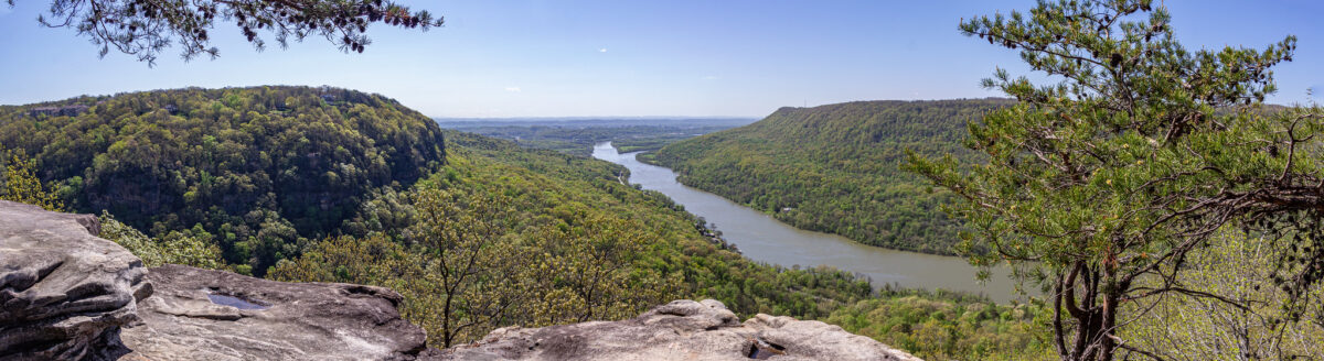
In related news, yesterday we went on a challenging mountain hike. You can read about that here. One section of the trail lead to a beautiful overlook, where we could see the mountains on all sides, the river and a waterfall.
It was a great metaphor for what I am going through right now. Yes, things are hard, but if you put just one foot in front of the other, you will eventually get to the top of your mountain. Derek and I have made it over mountains before, and we will get over this one, too.
Today we hiked a segment of the Cumberland Trail, starting from Signal Point in the town of Signal Mountain, and going as far as the Middle Creek suspension bridge before turning back, for a total of 2.8 miles.
For some odd reason, I thought this hike would be easier than the hike we did two weeks ago on Lookout Mountain. I was wrong! This hike was extremely rocky. There were very few spots where the trail was flat and even. There were many spots where we had to climb or duck under large trees that had fallen in the path! We just had a large storm pass through this week, so I’m not quite sure if a lot of those trees had always been there, or if some of the damage was new. There was one spot where a tree took out a small section of a wooden walkway, and that seemed new.
We started at Signal Point, and first enjoyed the overlook for a few minutes. The trail starts to the right, and almost immediately there are a ton of steep steps, known as “The Mousetrap.” I am not sure why it is called that, but this is what the internet told me!
After all of the steps, the trail starts out fairly easily, but gets quite hard! There were more rocky areas than flat areas. You had to look down with almost every step.
I was glad that the trail was well marked (white squares either in paint, or screwed into the trees as metal plates) because there were quite a lot of sections where we thought, “Is this really the way we’re supposed to go?”
At 0.4 miles into the hike, you reach Julia Falls Overlook. I have read online that the falls is usually dry, or just a trickle. I am glad that we went after two days of heavy rain, so we could see it!
We had Julia Falls Overlook all to ourselves for about 15-20 minutes. A few groups came in, but by that point we were ready to head on our way. (On the way back, after lunch time, there were quite a few people there.)
After that, we followed the trail for about a mile to the Middle Creek suspension bridge. We were by ourselves for about 5 minutes, and then all of a sudden so many people showed up! We think it’s because the bridge is close to the Rainbow Lake Trail, another popular area.
This hike was hard, but only because of the uneven ground. It was slow going, for sure. If I were to do this again, I would probably only do the first section to Julia Falls. As always, I am glad we did it, and I felt accomplished (and exhausted). This makes two mountain hikes in three weeks!
The Signal Point Overlook at the start of the trail.
Possible storm damage?
The view from Julia Falls Overlook. The waterfall is in the far right of the photo.
Last year Derek and I found a stretch of trees that really pop with color during the fall. The trees are on the edge of a elementary school parking lot, so it works out well to take photos there during the weekend.
We drove past that area early last week and noticed the reds and oranges. I was looking forward all week to taking more photos!
I love having our own, established spot. And I also love that it’s nearby, too.
I’m thankful that Derek is patient and takes many photos (literally over 150) so he knows for sure that I will like some of them. It’s quite funny that I snap about five photos of Derek, and he’s satisfied.
I love taking photos, mainly of outdoor related landscapes. I would say that my absolute favorite is fall leaves though. I’m truly happy when I’m photographing a colorful tree!
As I am writing this, everything in my lower body hurts! Yesterday Derek and I did a hike on Lookout Mountain. We picked the trail from Cravens House to Sunset Rock, which is 3 miles out and back.
Derek and I like to hike, but 3 miles is the longest we have ever hiked here in Chattanooga. Usually we stick to 1-2 mile trails. This is also the hike that I have wanted to do the most since first hearing about this particular trail.
A sign at the start of the hike says to allow one to two hours round trip, but it took us almost four. This included at least 45 minutes out at Sunset Rock, though. We also took our time on the way up, stopping for lots of photos along the way.
We went on a beautiful, cool October day, which means that the trail was busy. We had to step off to the side many times to let other groups come and go.
The scenery was gorgeous on the trail. About half way to Sunset Rock you walk alongside towering rock cliffs. We even saw some rock climbers!
The trail starts out quite easy, which can be deceiving. I think that the closer you get to Sunset Rock, the harder the trail gets. If you come here, make sure to wear good hiking shoes, and always look down while walking! The trail is extremely rocky in some sections. The last section of the trail is a set of very steep stone steps. It wasn’t so bad going up, but coming down was much harder. My legs felt like jelly after that!
Sunset Rock is the end goal of this hike, 1.5 miles from Cravens House. Sunset Rock is a large flat area of rock on the side of the mountain, offering some fantastic views.
“In late October 1863, Confederate Generals James Longstreet and Braxton Bragg stood on Sunset Rock on the western side of Lookout Mountain. Below was the Union Army, attempting to open a supply line through the valley. Longstreet and Bragg planned their attack, which culminated in the Battle of Wauhatchie on October 28-29, 1863.”
www.nps.gov
Sunset Rock was very crowded while we were there, but everyone was respectful of each other, and even though we had to wait at some of the areas, everyone got their turns to check out the different views and take pictures.
Derek got some fantastic pictures of me. I am excited about how they turned out. Yes, they do look a little daring, but I felt safe the whole time. Well, I did freak out a tiny bit thinking Derek was too close to the edge getting some shots of me.
I would think that to avoid a crowd at Sunset Rock, you would either have to hike early in the morning, or maybe in the wintertime. However, the Sunset Rock area is large enough that everyone had their own little sections to themselves.
The hike back is considerably easier, and faster since it’s a gentle decline.
Back in the parking lot, we checked out the Cravens House, owned by Robert Cravens, which was there during the Civil War. Some fighting during the Battle of Lookout Mountain occurred by the house on Nov. 24, 1863. After the battle, the Union troops used the house as headquarters.
I am currently reading The Smoke At Dawn by Jeff Shaara, which is about the Battles of Chattanooga, one book in a series about the Civil War. It was thrilling to have just read about that battle taking place on Lookout Mountain, and then to be there the next day!
I’m so glad that the weather has cooled down, and now we can resume hiking in full earnest! Last weekend we hiked the Blue Blazes trail, located in Moccasin Bend. This was our second hike in Moccasin Bend, the first one being the Brown’s Ferry Federal Road Trail. Read about that hike here.
To be honest, I’m not quite sure how long the trail actually is, because there is conflicting information. I saw it listed anywhere from 1.5 to 3 miles online, and the sign at the trail itself said it was 1.5 miles, but my phone recorded 2 miles worth of steps!
Either way, whether you think it is 1.5 or 3 miles, it is an easy, looped hike.
This is a woodsy trail, and the halfway point follows the river, with a path to get to the riverbank.
Another highlight of this hike is a swampy area that is covered in green algae. In that section, we found a tree that was heavy with fruit. We pulled some down and broke them open. They smelled like peaches. Don’t worry, we did not eat it! It was an interesting find though.
Yesterday was my birthday. To celebrate, we ate lunch at the Cookie Jar Cafe in Dunlap, Tennessee.
I had first heard about the Cookie Jar Cafe when I heard radio ads for Valentine’s Day reservations. I kept the name in my mind, tucked away for later.
Half of the draw of the Cookie Jar Cafe is the location. It is a family owned restaurant, and the family also owns a dairy farm on the same plot of land. While you’re waiting for a table (reservations are highly recommended) you can watch the cows grazing in the field.
The farm and restaurant are located in the Sequatchie Valley, so Walden’s Ridge looms overhead, making for a gorgeous backdrop.
They also have a small petting zoo behind the restaurant with goats, sheep, pigs and cows.
The food was excellent. I got a “meat and two” with chicken and dumplings, green beans and mac and cheese. An interesting side fact: I had never heard of a “meat and three” until I moved here. I figured it was a southern thing. Turns out it is, with its origins starting in Tennessee.
I am glad I went for the two sides instead of the three, because the portions were huge! It looked like I had barely made a dent on my plate. Next time I might try a sandwich. Derek got a burger with fries, and he said he enjoyed it, too.
The Cookie Jar Cafe is known for their desserts. We got an apple fry pie and a pumpkin spice cupcake to go.
On our way home, we stopped at the scenic overlook on the side of the highway, where we saw paragliders taking off.
It was a nice afternoon out. We will definitely come to the Cookie Jar Cafe again!
The outside of the Cookie Jar Cafe.
Such a beautiful scene!
The inside of the Cookie Jar Cafe. Notice all the cookie jars lined along the ceiling on the shelves! I even spotted my mom’s own cookie jar, a blue cat.
Happy birthday to me!
My meat and two. You can see Derek’s burger in the background.
The view from the scenic overlook on the way home.
I am counting down the days until cooler weather arrives, because I am looking forward to resuming hiking.
I have been Googling Chattanooga area hikes, and I am curating quite the list. It has been frustrating to discover all of these wonderful places, and know that it’s just not the best time to attempt a 3 mile hike.
This morning I was looking at hikes on Moccasin Bend. I found the Browns Ferry Federal Road Trail, and I got so excited about it, that we had to go right NOW.
The weather has been cooler all weekend because it has been raining on and off, and it was mostly cloudy, keeping the sun at bay. I had found the trail early in the morning, about 9:30, and convinced Derek to go. We were at the trail parking lot by 10 a.m.
The reason why I just couldn’t wait a few weeks is because the trail is a historic one, and I love history.
Browns Ferry Federal Road was a road in use since the early 1800s. A “trace” of the road on Moccasin Bend, as noted by signage on the trail, was discovered by LiDAR (Light Detection and Ranging), as well as the use of old maps. The trail opened up to the public in 2013.
In October 1863, the city of Chattanooga was under siege by the Confederates. The Union troops were starving, with no way to receive food supplies. The Union devised a plan to open up the supply line.
On Oct. 27, in the early morning hours, the Battle of Brown’s Ferry occurred.
Brig. Gen. William Hazen — fun fact, my last name is Hazen, no relation though, at least we think — commanded groups of men who floated down the Tennessee River in pontoon boats from the city of Chattanooga. They sailed around Moccasin Bend to the crossing site, Brown’s Ferry landing, which was in Confederate hands.
Sailing in the pre-dawn, they achieved the initial element of surprise and were able to cross the river, but were soon discovered by Confederate troops who fired upon them. Union troops were also waiting on the opposite bank (where we stood on the end of the trail) as reinforcements. Ultimately, the Union forces outnumbered the Confederates, who drew back to the south.
This allowed the Union to gain control of the road and open their supply line again. This supply line, and part of the battle became known as the “Cracker Line,” after the hardtack crackers that the soldiers ate.
It was exciting to stand there and picture the men coming up the river in the pontoon boats, as well as the man waiting in position on the shore, and imagine what they must have been thinking.
To see a map of the battle, and to read more about it, visit these two websites:
I own Jeff Shaara’s Civil War novels, one of which, The Smoke of Dawn, is about the Battle of Chattanooga. I have read them before, but not since moving here. I remember there being a chapter about the Cracker Line and the battle of Brown’s Ferry. I am looking forward to rereading this book again, even more so now.
In addition, Browns Ferry Federal Road was also an original segment of the Trail of Tears, or the removal of the Cherokee. This happened in 1838. The Cherokee also gathered around the same spot as the Union soldiers did, crossing the river.
The trail is a 1.2 mile out and back hike. It is mostly woodsy, with some open areas. We actually got lost. There was a section of the trail that looked like it went to the right, but it quickly became overgrown and it was obvious we went the wrong way. Looking at the AllTrails app put us back on the right track though.
It was a little muddy when we went, but that is probably because it has been raining all weekend. There are sections of the trail that have elevated boardwalks.
We saw some interesting flowers, butterflies, spider webs and even a couple of fresh deer prints. The trail ends at the river. A barge came through while we were there. We stayed there for a bit, enjoying the view, and imagining the history that occurred there.
Derek and I love coffee shops. You can read about some of the ones we frequent here.
The one thing I have missed the most during the pandemic is sitting inside a coffee shop. Getting to-go orders, or sitting outside, is just not the same. I miss the cozy ambience of being inside.
The only coffee shop we’ve never stopped going to is Rembrandt’s, because they have a large outdoor patio. I love going to Rembrandt’s, truly, but I ultimately want to rotate with the other places again.
Since the pandemic started, we have found two new coffee places. Except they’re not really places at all, which is best during a pandemic.
(Be) Caffeinated is a drive thru in Red Bank on Dayton Blvd, not far from where we live. It’s been open a little over a year. We had passed it multiple times, but never gave it a second thought. A drive thru is now one of the safest places you can go these days.
Again, as I’ve noted before, I can’t offer any opinions on the coffee. I only get chai lattes. However, at (Be) Caffeinated, Derek has ordered the Hazelnut Bliss as well as the Gig City Mocha. Derek says it is worth noting that their cold brew is strong. So strong that, getting a coffee in the early afternoon kept him up all night! We now know to go here in the morning.
A few months ago, when the Chattanooga Market opened up, we also discovered Spill the Beans, a coffee truck. At Spill the Beans, Derek has ordered the toffee nut cold brew. Spill the Beans’ schedule looks a little different these days, but normally you would find them at some of the bigger events in Chattanooga, as well as sporting events. We always look forward to going to the Market on weekends, and now Spill the Beans is included in that.
Our desire to get coffee and chai on the weekends has not waned despite the pandemic. At least we have these two options, which we will keep in rotation even after the pandemic has ended.
A couple of months ago I started to take pictures of pandemic related things — mostly signs in different locations — as a way to remember this unprecedented time when it’s all over.
Here are some of the pictures that I have collected.
Signs on Clumpie’s door.
A quarantine box to keep you occupied while you stay at home. A collection of items found in a store.
Stand here, please.
Eliminating the need to disinfect menus.
Stay healthy!
Derek on UTC’s campus, standing in a social distancing circle that was painted on Chamberlain Field.
The classroom where Derek teaches. His class is split into two groups, with half coming into class on one day, and the other half learning remotely. This allows the in-person group to keep physical distance.